
Data Visualization
The Hawaiʻi Sea Level Rise Viewer developed alongside the 2017 Hawaiʻi Sea Level Rise Vulnerability and Adaptation Report enabled community and government users to visualize and plan for the wide-ranging impacts of sea level rise across Hawaiʻi. The data visualization team is working to incorporate new CRC research and modeling results into an updated statewide viewer, as well as to build new products to best fit the needs of different communities. The team is also exploring virtual reality/extended reality and 3D visualization techniques to more effectively convey future impacts of sea level rise and climate change in Hawaiʻi.
For more info contact Matthew Barbee: mbarbee@hawaii.edu
Photo Description: Sea Level Rise Viewer Draft
Probability-based Sea Level Rise Flood Projection
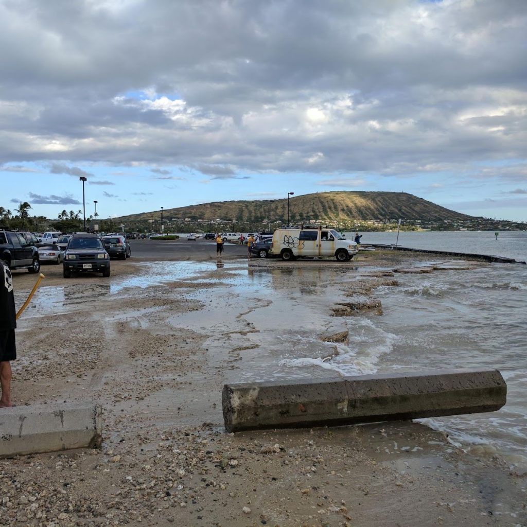
This project analyzes ocean surface height data from a Regional Ocean Modeling System reanalysis to produce an ocean reference surface as a proxy for local mean higher high water. This method allows incorporation of ocean surface level uncertainty into bathtub modeling and generation of probability-based projections of sea level rise-induced flooding. The team compares these projections to those generated using the Tidal Constituent and Residual Interpolation method, the standard method used by NOAA in insular areas of the U.S. where vDatum is not available.
For more info contact Noa Paoa: npaoakan@hawaii.edu
Photo Description: Coastal flooding near the Maunalua Bay Boat Ramp
Hawai’i and Pacific Islands King Tides Project
Hawai‘i and Pacific Islands King tides project. King Tides Map. (n.d.). Retrieved May 31, 2022, from https://www.pacioos.hawaii.edu/king-tides/map. html
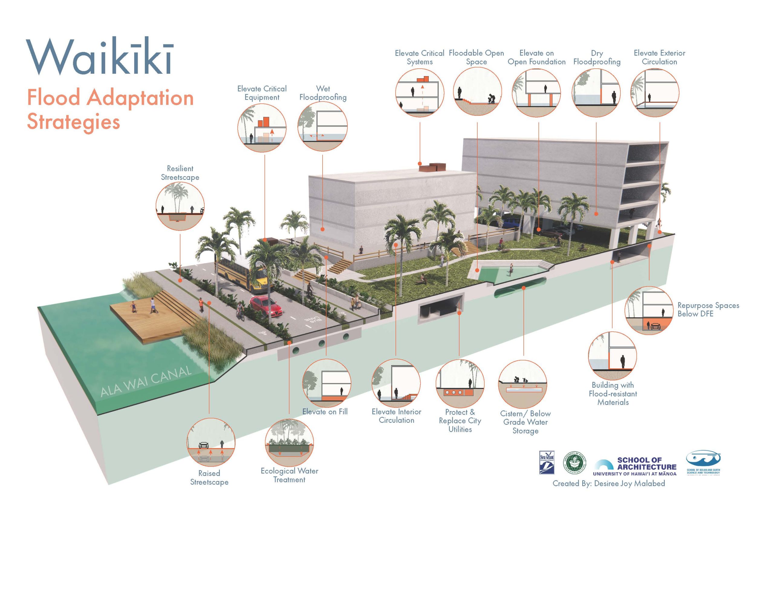
Envisioning Sea Level Rise Adaptation in Waikīkī
This design research project aims to visualize in-place adaptation strategies to address sea level rise for the coastal, urban context of Waikīkī throughout the 21st century. The process merges architectural design with climate science to create urban architectural renderings to incrementally adapt the city to the effects of climate change, including rising sea levels, more intense precipitation, and extreme temperatures.
First, faculty and students studied emerging flood resilience guides, exemplar buildings, and the latest sea level rise science. Second, the team identified the physical flood adaptation strategies with conceptual relevance for Waikīkī and solicited feedback on their relevance and feasibility from over 70 diverse, locally-based stakeholders. The feedback was compiled into a publicly-available report and used to inform the strategies selected for visualizations. In addition, the research informs policy with proposed methods for determining future design flood elevations for buildings. The team is continuing this research with other sites in Waikīkī to further develop adaptation strategies.
For more info contact Wendy Meguro: meguro@hawaii.edu
More Information
Photo Description: Architectural rendering by Desiree Joy Malabed of a site in Waikīkī
Sea Level Rise Induced Compound Flooding
Heavy rainfall events in Hawaiʻi produce widespread flooding, power outages, road closures and property damage across the state. Studies suggest these impacts will only be exacerbated by climate change, due to the compound effects of sea level rise and the likelihood of more frequent and intense storms reaching the islands. The team aims to develop a high-resolution flood modeling system based on the WRF-Hydro model framework. This research will provide inundation products of future flood scenarios in Hawaiʻi to help shape climate-related policy, mitigation and adaptation strategies.
For more info contact Kayla Yamamoto: kaylaky@hawaii.edu
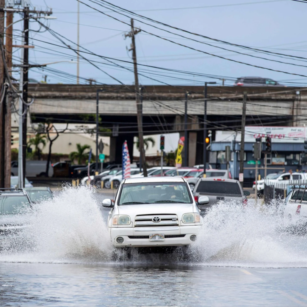
Photo Description: Flooding from December 2021 Kona Storm
Source: Start Advertiser
Michael Tsai mtsai@staradvertiser.comMay 27, 2017. (2018, September 13). Isles hunker down as King Tides Roll in. Advertiser. Retrieved May 31, 2022, from https://www.staradvertiser.com/2017/05/27/hawaii-news/isles-hunker-down-as-king-tides-roll-in/ Staff, H. N. N. (n.d.).

Monitoring Coastal Groundwater to Identify Sea Level Rise Related Infrastructure Impacts
The purpose of this research is to improve the understanding of coastal groundwater and how various phenomena (long-term sea level rise, tides, and rain events) influence its elevation. The position of the groundwater is an important consideration in infrastructure management owing to its known contributions to structural damage. Objectives of this effort include the development of a coastal groundwater monitoring network to improve simulations of sea level rise induced groundwater lift. Such simulations have been produced by this research group for Honolulu’s Urban Core and used to determine sea level rise induced vulnerabilities of low-lying and buried municipal infrastructure such as roadway and drainage networks. The monitoring will help to build upon past work by extending modeling to additional locations and by incorporating the influence of rainfall events, a main driver of groundwater elevation change. The primary purpose of producing these simulations is to inform planning and infrastructure management in consideration of elevated sea levels and changing climate.
For more info contact Shellie Habel: skey@hawaii.edu
Photo Description: Salinity measurement of groundwater inundation in a Waikīkī basement
Source: Chloe Obara
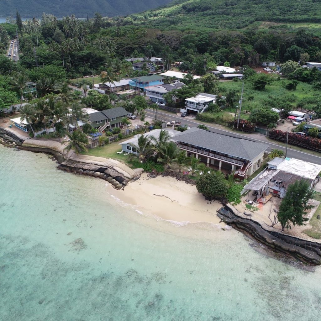
Monitoring and Modeling Shoreline Change
Hawaiʻi’s coastlines are complex and important systems affected by waves, terrestrial inputs, and sea level rise. As significant socioeconomic, scientific, and cultural spaces, it is critical to understand how these zones change over time and in the face of climate change. This project both monitors and models how Hawaiʻi’s beaches have changed since the early twentieth century. The team monitors beaches using high resolution GPS surveying, airborne and drone imagery, and satellite shoreline detection. Using this data, the team creates robust process-based models (CoSMoS-COASTS) that can predict future shoreline positions and coastal erosion hazard zones. These modeled results and accompanying imagery are used by policymakers and planners to inform setback laws and climate adaptation strategies.
For more info contact Richelle Moskvichev: rum@hawaii.edu
Photo Description: Punalu‘u O’ahu,
Source: Shellie Habel
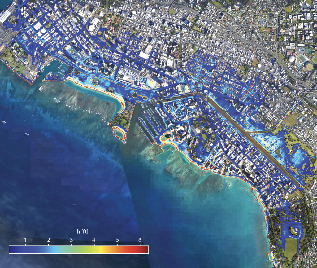
Wave Run Up
This team develops flooding event forecasts that enable coastal managers, emergency management personnel, property owners, and the general public to make more informed decisions about how to prepare for and respond to coastal erosion and flooding impacts. The hydrodynamic model used here was designed to account for all the wave-created phenomena that contribute to flooding at the shore, including swash, bore-on-bore capture, coastal seiches, set-up, and more, as sea level rises.
For more info contact Douglas Luther: dluther@hawaii.edu
Photo Description: Flood model simulation of a summer swell event in Waikīkī with a 5 foot sea level rise scenario
Source: Assaf Azouri
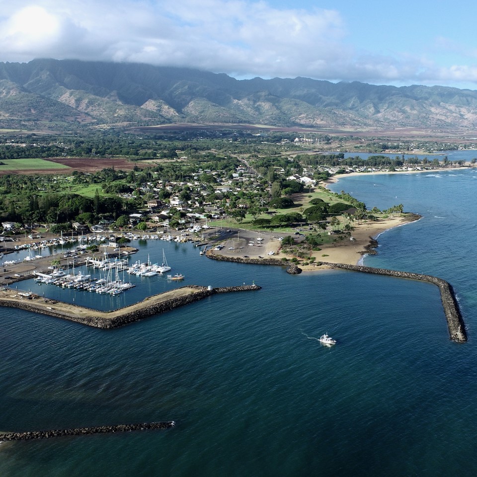
Extreme Tides
There are naturally occurring fluctuations in tidal range from one decade to the next. These fluctuations can paradoxically both reduce and exacerbate the impacts of sea level rise. This research seeks to understand and communicate tidal phenomena. Through the installation of tide gauges in harbors, they will be able to capture the water movement from the tides rather than wave action. The data will be used to validate ocean models, detect errors, and identify drifts in satellite altimetry. The team will monitor the gauges’ vertical stability every year so that sea level rise can be captured.
For more info contact Philip Thompson: philiprt@hawaii.edu
Photo Description: Haleiwa Harbor
Source: Kristian McDonald
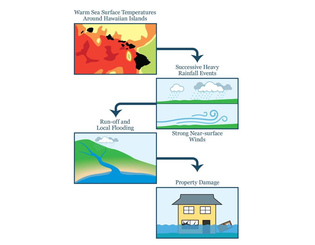
Physical Drivers of Heavy Rainfall Episodes Over the Hawaiian Islands in a Changing Climate
The team will explore the various physical drivers for the observed heavy rainfall events over the Hawaiian Islands. In particular, the team will investigate the individual and collective roles of both large-scale ocean-atmosphere processes and regional synoptic features. They include but are not limited to: (i) sea surface temperature anomalies in the North Pacific; (ii) atmospheric rivers; and (iii) Kona lows. To test overarching hypotheses, we will diagnose in situ and satellite-based observations for recent decades, in conjunction with designing numerical experiments with a high-resolution global climate model and apply suitable process-oriented diagnostics. The results will provide insight into the evolving rainfall characteristics over the Hawaiian Islands in a changing climate.
For more info contact hanna@hawaii.edu
Photo Description: Potential relationship between sea surface temperature and heavy rainfall events leading to property damage
Source: Brooks G. Bays
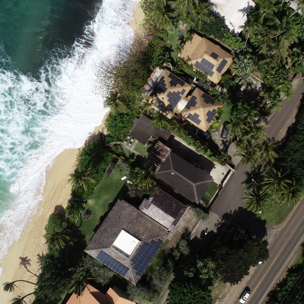
Identifying Costs and Tradeoffs in Sea Level Rise Response Strategies
Sea level rise (SLR) exacerbates existing coastal hazards and its impacts are already apparent throughout the coasts and low-lying areas of Hawaiʻi. Sandy beaches, a public trust resource, are at risk of disappearing due to the confluence of SLR and the historic and continuing hardening of the shoreline with coastal infrastructure. The project of the Institute for Sustainability and Resilience at the University of Hawaiʻi at Mānoa is assessing the costs and tradeoffs of potential SLR response strategies. We focus on retreat from the coast within a case study of the North Shore of O‘ahu. A variety of retreat scenarios are assessed based on their public and private costs, as well as in context to potential environmental harms to the public trust. This project serves to develop a framework for identifying and, to the extent feasible, measuring the variety of costs to SLR response in the context of development adjacent to Hawai’iʻs sandy beaches. Future work will expand on the concept of “protect, accommodate and retreat” to a broader set of urban typologies, including varying shoreline conditions and existing infrastructure.
For more info contact Makena Coffman: makenaka@hawaii.edu
Photo Description: Sunset Beach, North Shore of O‘ahu
Source: Anna Mikkelsen