
State of Hawaiʻi
Consideration of Sea Level Rise under the Hawaiʻi Environmental Policy Act
Description
In 2018, the Hawaiʻi State Legislature passed House Bill 2106 that became Act 17 which requires “all environmental assessments and environmental impact statements… whether in draft or final form, to include consideration of sea level rise based upon the best available scientific data regarding sea level rise.” Thus, any action that is subject to compliance with the Hawaiʻi Environmental Policy Act, HRS Chapter 343, must provide an applicable sea level rise exposure area map if it falls within the zone.
How CRC Data Would Be Used
The Sea Level Rise Exposure Area in the Hawaiʻi Sea Level Rise Viewer is comprised of data and modeling of high wave run-up, passive flooding, and coastal erosion, all generated by CRC researchers. Thus, any action that must comply with the Hawaiʻi Environmental Policy Act must also take into account whether the proposal will be impacted by sea level rise as mapped by CRC in the Hawaiʻi Sea Level Rise Viewer.
Disclosure Requirement for Residential Real Estate in the Sea Level Rise Exposure Area
Description
In 2021, the Hawaiʻi State Legislature recognized the importance of requiring sellers of real property in Hawaiʻi to disclose whether the property they are selling would be impacted by a meter of sea level rise. Senate Bill 474 (Act 179, 2021) amended Hawaiʻi Revised Statutes § 508D-15 to require that sellers of residential property in Hawaiʻi must disclose whether any portion of the property is within the sea level rise exposure area in the Hawaiʻi Sea Level Rise Viewer.
How CRC Data Would Be Used
The Sea Level Rise Exposure Area in the Hawaiʻi Sea Level Rise Viewer is comprised of data and modeling of high wave run-up, passive flooding, and coastal erosion, all generated by CRC researchers. Thus, CRC sea level rise modeling is now legally required to be disclosed by sellers of real property in Hawaiʻi to allow buyers to make informed decisions about residential property before it is too late.
City and Council of Honolulu
Special Management Areas – Revised Ordinances of Honolulu Chapter 25
Description
In March 2023, Mayor Honolulu Mayor Rick Blangiardi signed Bill 42 which updated Revised Ordinances of Honolulu Chapter 25, relating to the Special Management Areas, to incorporate amendments made by the Hawaiʻi Legislature in 2020 to the Hawaiʻi Coastal Zone Management Act. In addition, Bill 42 also incorporates new protections to Oʻahu’s coastal zone by including science-based planning considerations.
How CRC Data Would Be Used
Bill 42 incorporates CRC’s data by including a new consideration into the Special Management Areas permitting process. Specifically, ROH § 25-4.1(b)(6) states that would state that the City and County of Honolulu “shall seek to minimize, whenever reasonable…Risk to development from sea level rise and other coastal hazards, which may be accomplished by siting habitable structures outside of the sea level rise exposure area if feasible, or if not feasible adapting habitable structure within the sea level rise exposure area to accommodate sea level rise.”
Shoreline Setbacks – Revised Ordinances of Honolulu Chapter 2
Description
In March 2023, Mayor Honolulu Mayor Rick Blangiardi signed Bill 42 which updated Revised Ordinances of Honolulu Chapter 25, relating to the Special Management Areas, to incorporate amendments made by the Hawaiʻi Legislature in 2020 to the Hawaiʻi Coastal Zone Management Act. In addition, Bill 42 also incorporates new protections to Oʻahu’s coastal zone by including science-based planning considerations.
How CRC Data Would Be Used
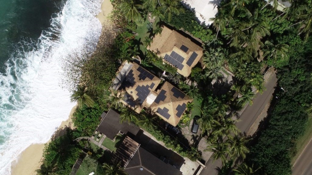
Bill 41 incorporates historical beach erosion data gathered by CRC researchers into the Oʻahu shoreline setback. Specifically, in most cases the shoreline setback is now a buffer of 40 feet, plus 70 multiplied by the average historical erosion rate for that particular section of beach. The maximum a shoreline setback may be is 130 feet from the state certified shoreline.

Resolution 22-239
Description
Urging the Hawaii State Legislature to appropriate funding to enable the Hawaii climate change mitigation and adaptation commission, in collaboration with the State of Hawaii Office and Planning and Sustainable Development’s coastal zone management program, to conduct certain activities to address sea level rise impacts.
County of Kauaʻi
Kauaʻi County Sea Level Rise Constraint District
Description
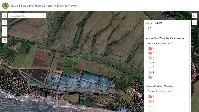
The County of Kauaʻi has a long history of responding to extreme weather events and flooding which have devastated and isolated its communities. In October 2022, the County of Kauaʻi became the first municipality in the nation to incorporate place-specific modeling of high wave run-up and passive flooding with a meter of sea level rise into its county building code. At its essence, Kauaʻi’s Sea Level Rise Constraint District requires new residential houses on the island to be built with the lowest level elevated above the depth of flooding and high waves with a 3.2 feet of sea level rise.
How CRC Data Would Be Used
CRC worked with the the County of Kauaʻi over the course of a couple years to translate the data compiled for the Hawaiʻi Sea Level Rise Viewer for passive flooding and high wave run-up into flood from distances from the shoreline into water depths (flood heights). This use of CRC data represents a new application of CRC’s coastal data and serves as a model for municipalities elsewhere in the country and world.
County of Kauaʻi Shoreline Setback
Description
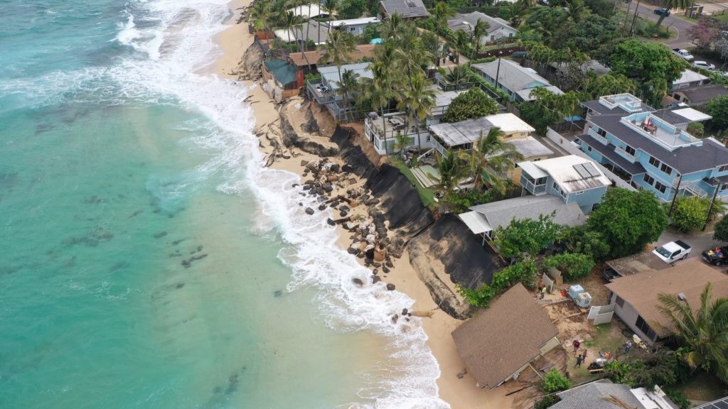
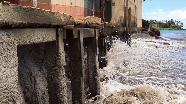
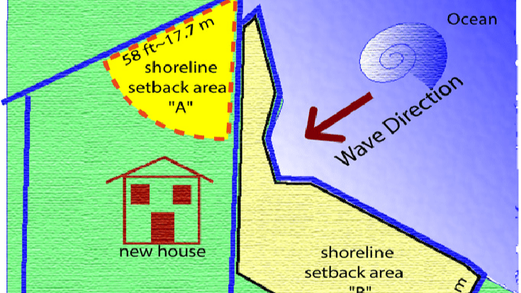
Shoreline setbacks are an important regulatory tool that municipalities can use to keep people and structures out of the way of the large waves that reach further inland each year due to sea level rise. At its essence, shoreline setbacks dictate how close to the state-certified shoreline a coastal property owner may build a structure or dwelling. In January of 2008, the County of Kauaʻi became the second municipality in Hawaiʻi and in the nation to enact a shoreline setback that incorporated an annual erosion rate-based shoreline setback.
How CRC Data Would Be Used
Kauaʻi’s shoreline setback defines the annual coastal erosion rate as “the long-term average annual rate of coastal erosion calculated by following the methodology outlined in the National Assessment of Shoreline Change: Historical Shoreline Changes in the Hawaiian Islands (Fletcher, et al., 2012).” This study was led by CRC’s director, Dr. Chip Fletcher, and the rates were calculated by CRC researchers, formerly the Coastal Geology Group, for every beach on Kauaʻi in 2010 and were updated in 2018.
The County of Kauaʻi’s shoreline setback ordinance states that for lots with an average depth of less that 140 feet, the setback line is equal to a buffer zone of 40 feet plus 70 multiplied by the annual coastal erosion rate, and in some cases an additional 20 feet. For lots with deeper depths, there is a larger buffer zone. The multiplier 70 serves as a benchmark for the average lifetime of a wooden structure.
County of Maui
Maui Planning Commission Chapter 203, Shoreline Rules
Description
Shoreline setbacks are an important regulatory tool that municipalities can use to keep people and structures out of the way of the large waves that reach further inland each year due to sea level rise. Under Hawaiʻi Revised Statutes Chapter 205A, the state delegates authority to each county to regulate shoreline setbacks. At its essence, shoreline setbacks dictate how close to the state-certified shoreline a coastal property owner may build a structure or dwelling.
The County of Maui currently incorporates an erosion rate-based calculation into its shoreline setback rules. For the most part, the shoreline setback in Maui County is calculated as “Twenty-five feet plus a distance of fifty times the annual erosion hazard rate from the shoreline.” There are other possible possible shoreline setback formulas based on lot size and shape, however, the County of Maui dictates that the setback must be the largest of the possible setbacks.
How CRC Data Would Be Used
The County of Maui incorporates CRC data into its shoreline setback by defining “Annual erosion hazard rate” as “the annual rate of coastal erosion calculated according to the methodology developed by the university of Hawaii along transects placed at regular intervals of approximately sixty-six feet and as indicated on maps on file with the department.”
Proposed Amendments to Chapter 203, Shoreline Rules
Description
Currently, Maui’s shoreline setback incorporates a rate-based calculation using CRC beach erosion data. The County of Maui Planning Department has been working for the past couple of years to propose updates to the County’s Shoreline Rules to take a more progressive approach. After much collaboration with the community, the Maui County Planning Commission is set to decide on whether and how to move forward with the proposed amendments.
How CRC Data Would Be Used
Maui County’s proposed amendments to its Shoreline Rules, Chapter 203, would incorporate CRC coastal erosion data at 3.2 feet of sea level rise. The Hawaiʻi Climate Change Mitigation and Adaptation Commission uses this data in the Hawaiʻi Sea Level Rise Viewer and the data and methodology has been peer-reviewed and published (Anderson et al., 2018). If passed, the County of Maui would call the coastal erosion line at 3.2 feet of sea level rise the “Erosion Hazard Line” and add an additional buffer as the general shoreline setback across the county.