Hawaii Big Island: Bathymetry

[ Bathymetry | Backscatter | Optical Validation | Benthic Habitat | Geomorphology]

5m Bathymetric data of Kohala coast of Hawaii 

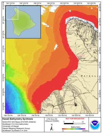
Download this image as a High-res JPG or PDF

Bathymetric data files


Benthic Habitat Data

Zipped data files contain , 1) JPG and PDF of image, and 2) explanatory metadata text file (identical to linked file listed below).* Ikonos imagery & USGS Digital Ortho Quarter Quads NOT included with download.


Bathymetry

5m Bathymetric data files

Not yet available

TOAD Coral Cover Map: West  Hawaiʻi
  • View: Metadata
    2012 | 2015 | Map
  • Download: Shapefiles, JPG & metadata
    ALL
Scleractinian Coral Cover & Sand Map: West Hawaiʻi
Dominant Benthic Structure and Biological Cover Habitat Maps for West Hawaii.
5m grid data

Zipped data files contain 1) Arc ASCII file, 2) layer (.lyr) file for symbology, 3) high-res JPG/PDF of image, and 4) explanatory metadata text file (identical to linked file listed below).

5m grid data