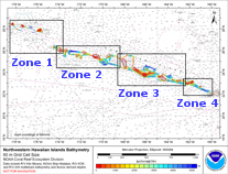
Click on the area names, for the Northwestern Hawaiian Islands, above to go to that data set page. Click in an unlabeled area to see a larger version of this map.
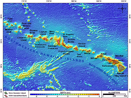
The Northwestern Hawaiian Islands (NWHI) are a chain of tiny islands, atolls and shoals that spans more than 2000 km of the Pacific. They stretch from Nihoa Island, northwest of the main Hawaiian Islands, to Kure Atoll, northwest of Midway. These islands, atolls and banks are remnants of volcanic islands, originally similar to the volcanoes of the Main Hawaiian Islands, which have eroded and subsided beneath the ocean surface. Geologically, the main Hawaiian Islands and the Northwest Hawaiian Islands make up the Hawaiian Archipelago, which was formed by active volcanism that continues today on the island of Hawai‘i. The main Hawaiian Islands lie at the southeastern end of the Hawaiian archipelago, with the uninhabited Northwest Hawaiian Islands extending toward Asia. The NWHI are uninhabited except for seasonal field camps on a few islands and a small year-round population on Midway. The coral reef ecosystems of the NWHI are unique in that they are some of the healthiest, most undisturbed coral reefs remaining in the world. The NWHI may be the last large-scale predator-dominated coral reef ecosystem on the planet.
In 2000 Executive Order 13178 created the NWHI Coral Reef Ecosystem Reserve (CRER) and included conservation measures to restrict some activities throughout the CRER. The region’s protected status was permanently signed into law in 2006 through Presidential Proclamation 8031, which established the NWHI Marine National Monument as the world’s largest marine protected area. It was subsequently renamed Papahanaumokuakea Marine National Monument.
NWHI Mapping Data Collected 2001-2005 |
|||||
| Cruise # Date |
Areas of Study | Single-beam w/QTC (km) | # Still Photos | # Videos | Multi-beam (km2) |
| TC0110 Sep-01 |
FFS, Brooks, St. Rogatien, Gardner, Raita, Maro | 2,963 | 297 | 9 | – |
| TC0111 Oct-01 |
Lisianski, Midway, Pioneer, FFS, Brooks, Necker, Maro | 1,717 | 640 | 5 | – |
| TC0207 Sep-02 |
Necker, FFS, Laysan, Pearl & Hermes, Lisianski, Midway, Kure, Maro, Brooks, St. Rogatien, Pioneer | 1,309 | 902 | 13 | – |
| KM206 Oct-02 |
Nihoa, Necker, FFS, Brooks, Gardner, Raita, Maro, Lisianski, Laysan, Pioneer, Northhampton Seamounts | – | – | – | 38,367 |
| OES0306 Jul-Aug 03 |
FFS, Gardner, Maro, Laysan, Lisianski, Midway, Pearl & Hermes, Kure | 650 | 1,894 | 67 | 240 |
| HI0401 Sep-Oct 04 |
FFS, Maro, Laysan, Pearl & Hermes, Midway, Kure, Lisianski, Necker | – | – | 85 | – |
| HI0501 Apr 05 |
Nihoa, Necker, FFS, East Brooks | – | – | – | 371 |
| HI0503 May-Jun 05 |
FFS, East Brooks, Maro, P&H, Midway, Kure | – | – | 12 | 870 |
| HI0504 Jun-Jul 05 |
Ni’ihau/Lehua Rock, Penguin Bank, Molokai (north shore) | – | – | 4 | 880 |
| HI0505 Jul 05 |
Ni’ihau/Lehua Rock, Kauai, Oahu, Molokai, Lanai, Maui | – | – | 28 | 246 |
| HI0507 Aug-Sep 05 |
Surveys of opportunity during NWHI RAMP by survey tech. | – | – | – | not totaled |
| HI0508 Oct 05 |
Maro Reef & seamount west of Kauai |
– | – | – | 516 |
| TOTALS | 6,639 | 3,733 | 191 | 40,364 | |
Mapping in the NWHI is on-going and multibeam surveys are planned on an annual basis. The bank top areas between 20 and 100m are extensive and still mostly unmapped; for example, Necker Island has an unmapped area of almost 1500 km2 and Gardner Bank, over 2200 km2. Shallow water surveys such as these are very time consuming; typical progress is about 2 km2/hour. Individual mapping priorities are being established by CRER, CRED, and other groups working in the NWHI. Upcoming multibeam surveys are planned first in areas where RPA boundaries are still incomplete, such as Kure, Pearl & Hermes, and Nihoa Island. We will also continue to collect optical validation data whenever possible, in order to provide ground truth information to help interpret the detailed bathymetry data after it has been collected.

