[ Bathymetry | Backscatter | Optical Validation | Geomorphology ]
Kauai, the oldest and northwestern most of the large Hawaiian islands, is also home to the wettest place on earth (Mount Waialeale). These factors have combined to erode any trace of the volcano’s original shape, leaving the most complex terrestrial geomorphology of all the Hawaiian islands. Kauai is 1430 sq. km in area, reaches 1598 m at Kawaikini, has 145 km of shoreline and an estimated reef area of 266 sq. km. The island is roughly centered around 22° 05’N, 159° 30’W, which makes it the most removed island from the magma-producing hotspot, along with Niihau. Kauai is separated from Niihau by only 21 km, but the channel between them is 1097 m deep. Like all of the main Hawaiian islands, it is considered a high island and contributes significant nutrient and sediment runoff to coastal waters. The human population was counted at 50,947 in 1990.
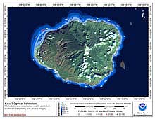
Click thumbnail maps below to explore PIBHMC’s data sets.
Bathymetry |
Backscatter Imagery
Not yet available
|
Optical Validation |
Geomorphology
Not yet available
|

