[ Bathymetry | Backscatter | Optical Validation | Benthic Habitat | Geomorphology ]
Bathymetric Gridded Data
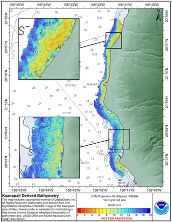
DigitalGlobe’s(DG) WorldView-2 data are used as the base imagery to derived pseudobathymetry of the Kaanapali area of Maui. This area has both SHOALS and multi-beam acoustic derived bathymetry coverage and will provide an example case of the strengths and weaknesses of pseudobathymetry extraction from high resolution satellite imagery methods.
Derived bathymetry of nearshore benthic habitats near Kaanapali, Maui
10 meter grid
Download this image as a High-res JPG or PDF
Bathymetric data files
- View Metadata: Metadata text
- Zipped data: Arc ASCII (7.6mb)
Methods used were adapted from a “cookbook” of instructions developed by Kyle Hogref for using IKONOS imagery data to derive seafloor elevations in optically clear water. This dataset was derived from high-resolution (2 m) imagery from DG’s WorldView-2 sensor of the Kaanapali area of Maui, Hawaii. Sensor bands 1,2 and 5 (coastal, blue and near IR respectively) were used to derive depth information. The method assumes unifrom water clarity but deviations from that condition made extraction difficult in water greater than 30 m depth in the Kaanapali scene used. Results show that biotic material or sediment in the water column skewed results shallower if the material has a high albedo and deeper if the material has a low albedo. Nearshore areas were signifcantly less impacted in the Kaanapali area, due to the geomorphology of the area and the hi resolution and quality of the imagery, allowing visual descrimination of apparent sediment in the water column. For presentation purposes the map product shows an Inverse Distance Weighted interpolated bathymetry surface, restricted to data within 600 m of the shoreline.
