Oceanographic Monitoring and Forecasting
Focused on the Pacific Ocean Basin, research under this theme is associated with the collection and analysis of physical, biological, and chemical observations of the ocean that will yield valuable information about large-scale ocean property distributions and currents, including their variability over long time scales.
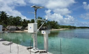
University of Hawai‘i Sea Level Center (UHSLC)
The purpose of UHSLC is to ensure that tide gauge data from around the world are collected and distributed, for use in monitoring and research applications related to climate and oceanography. The UHSLC fulfills this purpose via two activities: first, the UHSLC is a primary data center in the international Global Sea Level Observing System, curating and distributing tide gauge datasets. The Research Quality database is maintained in collaboration with the National Oceanographic Data Center, and toward this purpose, the UHSLC acquires tide gauge data from nearly 500 tide gauge stations maintained by 65 international agencies. Second, UHSLC collaborates directly with international partners to maintain more than 80 high-profile water level stations that are essential for the sea level and tsunami observing efforts. UHSLC involvement ensures that research-quality and near-real-time monitoring datasets are available from otherwise sparsely sampled areas of the global ocean, and that developing nations have access to training, technical support, and data processing services as needed.Read more in the Annual Reports.
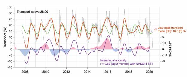
Observations and Dynamics in the Solomon Sea
The equatorward boundary current in the Solomon Sea is the primary pathway by which waters from the subtropical South Pacific reach the equatorial zone. It is a crucial pathway of the ocean circulation that supports climate variability in the Pacific and enables the long term “memory” carried by the ocean. Underwater gliders are used to make 12-16 transects each year crossing the Sea to gather data; analysis of the resulting 11-year time series tells us how and why transport and water properties vary; and how these interact with the El Niño/Southern Oscillation (ENSO). This project’s objective is to produce, study, and publicly distribute products that would enable wider use of the data by the team and others — this would include modelers and ENSO/ climate analysts. The result would foster improved modeling of this key piece of the tropical Pacific climate system. Read more in the Annual Reports.University of Hawai‘i Sea Level Center: cGPS
Vertical land movements can significantly alter the rates of sea-level rise expected from the sole climatic contributions of ocean thermal expansion and land-based ice melting, possibly magnifying the impacts of sealevel rise on the coast. This motion can be determined through continuous measurements of the Global Navigation Satellite System (GNSS) at tide-gauge sites, and GNSS sites are required for all tide-gauge stations within the Global Sea-level Observing System Core Network (GCN). This project will install, maintain, and handle the data flow from GNSS sites at GCN tide gauge operated by the University of Hawai‘i Sea Level Center. Read more in the Annual Reports.