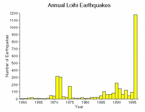
Seismicity at Loihi Volcano

Visit USGS-HVO for real time quake monitoring info at https://volcanoes.usgs.gov/observatories/hvo/hvo_earthquakes.html
|
SMALL EARTHQUAKE SWARM AT LOIHI in June 2017
A swarm of quakes (a few per day) is currently underway at Loihi. The map at right shows the last 2 weeks of activity at the Big Island and Loihi (off the south coast). It is an annotated screen grab from the USGS HVO moitoring network https://volcanoes.usgs.gov/observatories/hvo/hvo_earthquakes.html. |
 |
|
SMALL EARTHQUAKE SWARM RATTLES LOIHI IN DEC 2005
The USGS-ANSS (Advanced National Seismic System) reports that small swarm of about 100 quakes (the largest 3 were about 4 magnitude and between 12 and 28 km deep) occured beneath Loihi on Dec. 7 2005. A more recent quake (estimated magnitude of 4.7) occured on 18 Jan 2006, roughly midway between the Loihi and Pahala (on the S. Coast of the Big Island).
LARGEST EARTHQUAKEs TO HIT LOIHI IN 2005....
|
 |
|
Septermber, 2001 - MULTIPLE EARTHQUAKES DETECTED AT LOIHI SINCE 10 SEPT 2001
Increased seismicity in the form of a swarm of earthquakes began at Loihi's summit with quakes up to magnitude 4.7 on 10 sept 2001. The significant of increase in seismic activity indicates renewed strong tectonic and/or magmatic activity near the summit reagion of the seamount. Activity began with magnitude 4.5 to 4.7 events on 10 Sept. and continues for a couple of weeks with quakes up to magnitude 5.2. The image below shows some of these events superimiposed on a bathimetric map. Note that the locations of these events are still highly preliminary. For instance, the apparent south rift zone trend on the map is suspect due to these events having been recorded on by shore stations to the north and west of the seamount. Shore station locations result in an location error ellipse that follows the Loihi rift zone trend. The much larger 1996 swarm also looked elongated along the south rift until events were later relocated using a refined velocity model based on events detected using an ocean bottom seismometer located on the seamount's summit. |

|
|
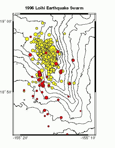
The 1996 Loihi Earthquake Swarm
On July 16th, 1996, Loihi seamount began to shake with earthquakes. In the two weeks that followed, over 4000 Loihi earthquakes were detected by the Hawaii Volcano Observatory's (HVO) seismic network, making this the largest earthquake swarm ever recorded on a Hawaiian volcano. What IS an Earthquake Swarm?
What are swarms on Loihi like?
|
Obviously, the swarm of 1996 was unlike any previously measured swarm. |
The figure to the right shows epicentral locations for approximately 1000 of the events which took place during the 1996 swarm. The majority of events seem to cluster near Loihi's summit, while others spread over the south and west flanks of the volcano. On this plot, the red circles represent earthquakes which took place in the first few days of the swarm. Then there was a day of quiet on Loihi...no earthquakes were recorded on July 19th. But on July 20th, the swarm started up again with a vengeance. The yellow circles show the locations of events which took place in the later phase of activity. Notice that the early (red) earthquakes were located nearer the southwest flank of the volcano while the later (yellow) events cluster near the summit. Other events were either too small to accurately locate, or occurred almost simultaneously with other earthquakes and were therefore difficult to time. Some of the questions we hope to answer with this data are: Why were there two phases of activity? Why did earthquake locations change during those two phases? How do the earthquakes relate to the eruption and to the formation of a pit crater on Loihi's summit? |
|
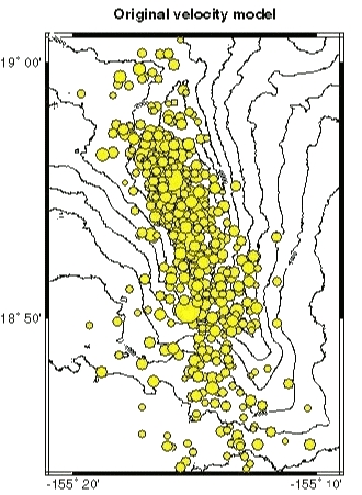
Loihi Velocity Models
In order to determine where an earthquake took place, we need to know how fast the seismic waves move within the ground. A "velocity model" describes what we think the speed is at different depths under the ground. Not only is it one of the most important tools used in earthquake location, it is also very useful in examining the geology of those parts of the volcano that we cannot see. For example, an anomalously slow area may indicate the presence of a magma chamber (because molten rock retards the rate at which seismic waves travel) while a high-velocity region may be an area with dense, cool intrusive rocks.
Initially, we located the Loihi earthquakes
using the same velocity model used beneath the Big
Island of Hawaii and believed that the quakes
were spread along the south rift of Loihi. These
locations are shown below:
 |
Using a new velocity model, in which seismic waves
move much more slowly beneath Loihi, we find that
the earthquake locations change. The new locations
are shown below. Notice that they are clustered
much nearer the summit.
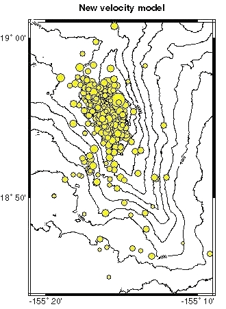 |
Depths can only be constrained for a few of the 1200 events, but for those earthquakes we find that they lie at depths of 7Ł8 km beneath Loihi's summit. These depths are consistent with petrologic studies of Loihi rocks which suggest that Loihi's magma chamber lies just below same depth. This was one of our first clues that the earthquake swarm may have been directly associated with the movement of magma within the volcano.
![]() Hawaii Center for Volcanology LOIHI Page
Hawaii Center for Volcanology LOIHI Page
 Hawaii Center for Volcanology Home Page
Page content by Jackie Caplan-Auerbach,
jackie@soest.hawaii.edu
Last page update on 23 June 2017
Page maintained by
Ken Rubin©,
Other credits for this web site.