Pacific ENSO Update
4th Quarter, 2004 Vol. 10 No. 4
SPECIAL SECTION: ENSO and Sea-Level Variability (2):
Physical Mechanism
(Guam, Marshalls, and American Samoa)
This is the second article of a series by Dr. Rashed Chowdhury on predicting sea level variations for the US Affiliated Pacific Islands. Last issue focused on the historical differences in sea level and the ENSO Cycle; this issue focuses on the physical mechanics behind these differences.
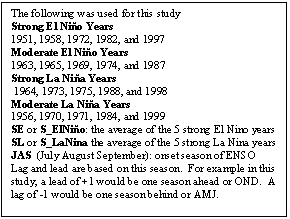
Figure 3 represents the monthly sea level responses to El Niño-Southern Oscillation (ENSO) events. Because an ENSO event generally develops in summer, reaches its peak in winter, and continues through the next spring, a composite of seasonal variations of sea level is useful from July (onset of ENSO year or year 0) to June of the following year (year +1). In the USAPI North Pacific Islands (i.e., Guam and Marshalls), the monthly average sea level deviation is negative and generally decreasing during strong El Niño years Fig.(3a, 3b). This is very distinct from time of the onset of ENSO in July/Aug/Sep (or JAS) and continues up to Jan/Feb/Mar (or JFM) of the following year. Strong El Niño years have recorded significantly lower than average sea level (4 to 6 inches) during these months (JAS, Oct/Nov/Dec or OND, and JFM). Moderate El Niño years also recorded lower than average (2 to 5 inches sea level - only the magnitude being smaller than before). So, a linear relationship between the strength of El Niño and sea level fall in Guam and the Marshalls is strong. Similar linear relationships exist in case of La Niña years too, both the strong La Niña and moderate La Niña years recorded higher than average sea level (4 to 6 inches for strong and 2 to 5 inches for moderate) in these months.
In contrast, sea level in American Samoa did not vary significantly during most JAS to OND (lead +1) of these strong and moderate El Niño years (Figure 3c). Similar trends were observed in La Niña years. However, consistent with previous findings in the North Pacific Islands, El Niño years produced pronounced fall (4 to 6 inches) in sea level and La Niña years produced significant sea level rise (3 to 5 inches) in American Samoa during JFM (lead +2) and AMJ (lead +3). With respect to Guam and Marshalls, this is an indication of a six month lag relationship of sea level variations in American Samoa. The physical mechanism that drives this lag relationship is explained in the following section.
The monsoon subsystems - the Asian, Indian and African monsoons - are connected to variations in sea surface temperature (SST) in the tropical Pacific Ocean. These, in turn, are linked, to some extent, to the El Niño - Southern Oscillation (ENSO). Composite averages of SSTs and surface wind circulation anomalies for five strong El Niño minus five strong La Niña years are presented in Figure 4. ENSO develops in JAS, so, starting from the previous -OND (three seasons lag or lag -3 with respect to JAS) and extending up to +JFM (two seasons lead or lead + 2 with respect to JAS), SSTs and atmospheric circulations have been analyzed in Figure 4.
Figure 4 shows the differences of SSTs between the strong El Niño and strong La Niña years (as represented by SE - SL). It shows, as compared to S_LaNiña, the average warming of SSTs in the region of South-central Pacific is much higher during the S_ElNiño years (Figure 4: left panel). The warming of SSTs starts from the preceding AMJ (lag -1), strengthens through JAS and OND (lead +1), and continues up to JFM (lead +2). Looking back from the OND (lag -3) of previous year, the SSTs in the central and eastern tropical Pacific slowly fluctuates across the Niño 3.4 region, such that in strong El Niño years, SSTs are cooler than average during OND (lag -3) and JFM (lag -2). The SST pattern provides a picture, as compared to the preceding OND (lag -3), the SSTs in JAS indicate an opposite sign of relationship (biennial signal). The moderate ENSO years indicate similar trends of SSTs but with weaker strength.
Figure 4 (right panel) shows the differences in atmospheric circulations between strong El Niño and strong La Niña years (as represented by S_ElNiño - S_LaNiña). The S_ElNiño years experience stronger westerly winds in the equatorial western/central Pacific compared to S_LaNiña years. It has been observed that initially the easterly is active in OND (lag -3) (Figure 4: right panel). As the year advances, the westerly became active in AMJ (lag -1) and gradually strengthens in JAS (lag 0: onset of ENSO), and continues up to JFM (lead +2) in north to north-western region of the Pacific. These reverse and strong trade-winds cause water to pile up in South America. As a result, the North Pacific Islands (Guam and Marshalls) starts experiencing significantly lower sea level, while the sea level in South Pacific Islands (e.g., American Samoa) remains unchanged. However, during OND (lead +1), the westerly winds shift towards the central region of Pacific. By JFM (lead +2), the westerly winds strengthen and move to the center to south central region. Due to the shift of tradewinds, American Samoa experiences a sea-level drop with a time lag of 3-6 months, as compared to Guam and Marshalls.
The persistence of tropical sea surface temperature, such as those associated with El Niño and La Niña play a fundamental role in determining seasonal (3-month) forecasts for sea level variability in the USAPI. Therefore year-to-year monitoring of the SST and atmospheric circulation patterns provides substantial opportunities to create an outlook of sea level variability and climate extremes in the USAPI.
d