Monthly Climate and Impacts Report for Hawaii - April 2013
Chris O'Connor and Dr. Pao-Shin Chu
Hawaii State Climate Office
Department of Meteorology
University of Hawaii
Honolulu, HI 96822
Precipitation and Temperature
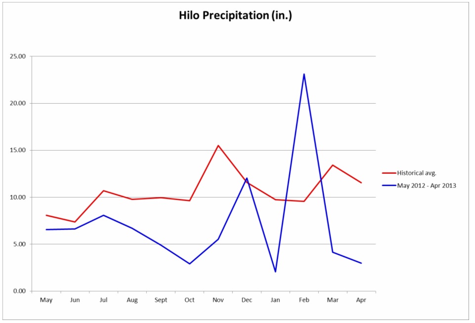
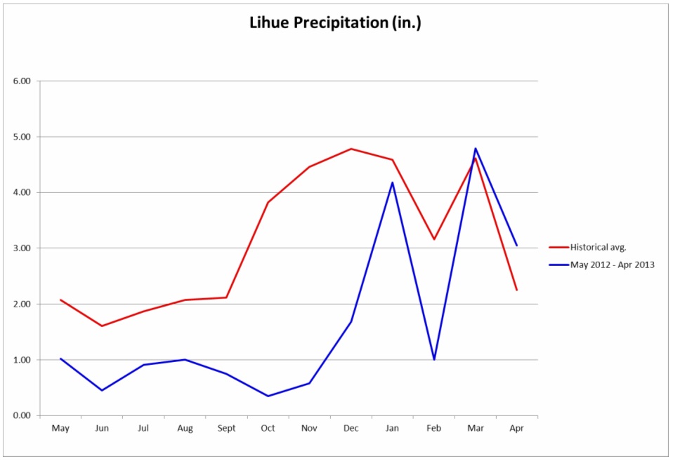
The first two months of the spring season have brought improving trends in rainfall amounts to the western islands, while the eastern islands have experienced drier than normal conditions. April produced a good amount of moisture for the state, most significant in the western islands. This month saw significantly above average rainfall amounts in some areas of the state, while other areas saw less than a quarter of the normal levels. This polarized precipitation trend can be generalized by splitting the state into eastern and western areas. The eastern section saw drier than normal conditions while the western section of the state experienced wetter than normal conditions. Kahului experienced extremely below average rainfall amounts (~4.52% of normal) for the second time in two months. Hilo experienced slightly more rainfall than Kahului however still much less than the normal amount of rainfall (25.74% of normal), which is a sharp contrast to the immense amount of precipitation Hilo experienced in February (over 200% of normal precipitation). Oahu and Kauai, the western section of the state, was much more fortunate than their sister islands, pulling in well above average rainfall amounts. Honolulu experienced an incredible amount of precipitation (277.78% normal rainfall) while Lihue saw 135.56% normal rainfall. As a result of the increase in precipitation especially in the western portion of Hawai'i, drought conditions in the western part of the state have seen a continued improvement from previous months. Kauai has improved to drought free conditions, while Oahu is almost completely drought free! The eastern islands however have seen a slight increase in drought this spring. Here there are still areas of drought ranging from "Abnormally Dry" (D0) to "Extreme Drought" (D3) on a scale of D0-D4. The big picture: thanks to a couple of healthy months of rainfall during winter and the beginning of spring, drought conditions have improved greatly in the western part of the state and continued in a neutral state in the eastern part of the state!
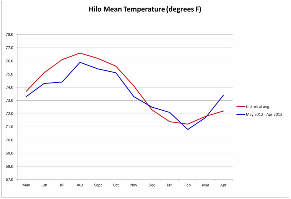
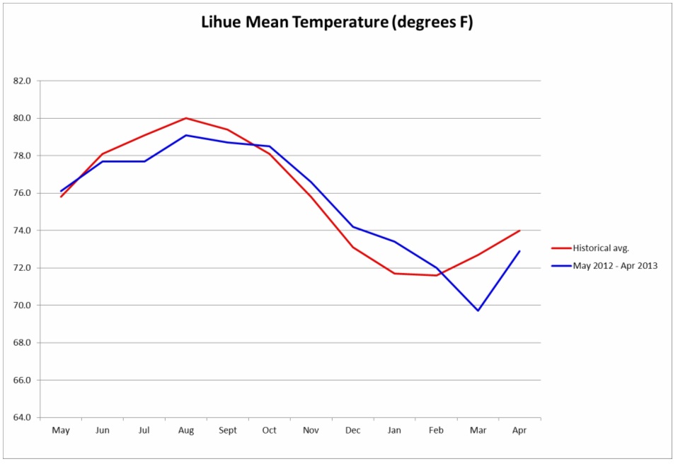
Temperature anomalies were very interesting this month. Just as the state experienced di-polar precipitation regimes, temperature regimes can be split into two sections: eastern and western islands. In the eastern Hawaiian islands, the mean temperatures as well as mean highs were above their respective historical averages, while mean lows were below their respective historical averages. In the western Hawaiian islands, the mean temperatures as well as mean highs and mean lows were below their respective historical averages. This is most likely due to a couple significant systems felt throughout the month which brought heavy rain and cloud cover to western portion of the state.
The NOAA Climate Prediction Center seasonal outlook for Hawaii predicted equal chances for above, near, and below normal temperatures for the Hawaiian Islands in May 2013. They also give no indication of either above or below median precipitation for Hawaii in May 2013.
ENSO
During March 2013, ENSO-neutral continued, with slightly above average SSTs in the eastern portion of the basin. Weekly values of all the Nino indices were between -0.5°C and +0.5°C during the month. The oceanic heat content (average temperature in the upper 300m of the ocean) increased to near-average during the month as an area of above-average temperatures at depth moved eastward into portions of the eastern basin. The Madden-Julian Oscillation (MJO) again contributed to increased atmospheric variability over the tropical Pacific. Low-level winds were near average, and upper-level winds were anomalously westerly across the equatorial Pacific. Convection was enhanced over the western equatorial Pacific and suppressed in the central basin. Collectively, these features indicate the continuation of ENSO-neutral. ENSO-neutral is favored into the Northern Hemisphere summer 2013.
Impacts
April 2013 saw some very interesting activity in terms of weather in the state of Hawai'i, as several records were set concerning precipitation and temperature. On Tuesday and Wednesday 4/2/13 and 4/3/13, unseasonably cool air set record lows in Honolulu, Hilo, and Lihue. Then on Saturday 4/6/13, a record high temperature of 90 degrees was set at Kahului airport. The entire week of 4/8-4/15/13 saw multiple temperatures records being broken, and record highs were experienced state wide. The cause of these high temperatures was continued days without trade winds, causing for unusually high daytime temperatures.
There was one rainfall event which set a record this month, occurring at the Honolulu airport. On Monday 4/22/13, a record rainfall of 0.56 inches was observed.