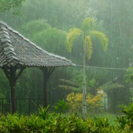
Rain and clouds over terraced land in Indonesia. Credit: PixelPlacebo, CC-BY-NC-2.0.

Daily rainfall over Sumatra linked to larger atmospheric phenomenon

Around the globe, communities are concerned with rain and storms. An area known as the “Maritime Continent,” which includes major islands such as Sumatra, Java, Borneo, Papua New Guinea, along with a galaxy of smaller islands, experiences significant rainfall including periodic monsoonal rain, and flash flooding.

In a new study led by SOEST atmospheric scientist Giuseppe Torri, researchers revealed details of the connection between a larger atmospheric phenomenon, termed the Madden-Julian Oscillation (MJO), and the daily patterns of rainfall in the Maritime Continent.

The MJO circles the globe around the tropics and can affect weather on weekly to monthly time scales, alternately bringing cloudy, rain periods and sunny, drier periods.

Torri and co-authors found that the impact of the MJO on the daily rainfall patterns of Sumatra was quite significant. When the MJO was active near the Maritime Continent, there was more water vapor—and therefore greater potential for significant rain events—and more variations in water vapor throughout the day as compared to the suppressed phase. Also, clouds and rain seemed to move offshore at night faster during the active phase of the MJO.

The team relied on data from a network of GPS stations that were installed on Sumatra and on the neighboring islands by a team of scientists interested in monitoring tectonic activity along the western coast of Sumatra. As it turns out, the GPS signal is distorted by the amount of water vapor in the atmosphere. This distortion is bad news for people interested in location information—which is what the GPS technology was invented for. However, scientists, including UH Mānoa atmospheric sciences professor Steven Businger, realized that the distortion can tell us something about the state of the atmosphere and pioneered its use as a source of data.

With the extensive coverage of the GPS stations on the island of Sumatra, the team had a dataset that provided a highly detailed picture of the daily atmospheric changes.

“Given the existing scientific literature, we had a sense that the MJO had an impact on the local convection in the Maritime Continent,” said Torri. “One thing that was surprising to me was just how well we could see the convection propagate offshore in the late evening. This is thanks to the density of stations of the GPS network we considered.”

The MJO is arguably one of the most important phenomena on the planet, and can influence the weather and the climate of regions that are even thousands of miles away from the Maritime Continent. A better understanding of the MJO, and a good way to simulate it are key to better understanding our current and future climate.

While the current study furthers understanding of the impacts of the MJO on clouds and rain over Sumatra, Torri will team up with SOEST atmospheric scientist Alison Nugent to investigate the causes of these impacts and the mechanisms that control the offshore propagation of rainfall.

Read more on UH News.

Could the world’s cargo ships help with tsunami detection?


James Foster, associate researcher in the Hawaii Institute of Geophysics and Planetology (HIGP), is continuing his efforts to utilize the international cargo shipping fleet to improve tsunami detection and warning. With high quality global positioning systems (GPS) on ships and regular feedback to the shore, Foster found irregular waves as small as 10 or 20 centimeters high could be detected to boost early warning systems and save tens of thousands of lives.

Today, tsunami warnings are issued when the large earthquakes which can cause tsunamis are detected. Dr. Foster’s idea can help verify if a tsunami was actually generated, and how large it is, if a cargo ship happens to be traveling near where the earthquake happens.

“But there is actually a good chance of that if we are able to equip most of the cargo ships in the world with this sort of system, which tend to be traveling through those sorts of areas all the time,” Foster said. “Otherwise, they will know there is a large earthquake but there is still some uncertainty as to whether it has actually created a dangerous tsunami or not.”

The process works using three dimensional precise positioning, taken as often as possible from the ship out at sea. If an earthquake occurs, the ships near that location can begin sending their position to early warning centers who can measure the height of the waves and look for those very long period 10 centimeter plus waves that signal a tsunami. This process basically happens in real time, Foster said. The only wait is the time it takes the waves take to pass beneath the ship, which can take anywhere between 10 and 30 minutes.

Foster was compiling and analyzing data when Eric Roeder, a United Nations official working on disaster and climate risk reduction came across his work and decided to act. Roeder put together a roundtable, called Maritime Sector Strategies to Augment Tsunami Monitoring with Economic, Safety and Environmental Co-benefits, and gathered private and public sector representatives in late August to discuss it.

That is where Foster met China Navigation Company’s Simon Bennett, the general manager of sustainable development, who did not hesitate before throwing his support behind the idea. This new partnership between China Navigation and Foster will kick-start the next phase of the project to further improve the amount and consistency of data streaming in from cargo vessels.

Read the full story on Samoa Observer.

Abundant schools of reef fishes swim through vibrant branching coral thickets on an Indonesian reef. Credit: Erik Franklin, UHM HIMB.

Largest study of coral communities identifies solutions to protect reefs

The largest study ever conducted of its kind has identified where and how to save coral reef communities in the Indo-Pacific, according to an international group of scientists that included University of Hawaiʻi (UH) at Mānoa researchers Erik Franklin, Camilo Mora, and Kuʻulei Rodgers and others from conservation NGOs, government agencies, and universities. The study outlines three viable strategies that can be quickly enacted to help save coral reefs that are threatened by climate change and human impacts—protect, recover, and transform.

Published in the journal Nature Ecology and Evolution, the study involved the efforts of more than 80 authors who surveyed coral abundance on more than 2,500 reefs across 44 countries in the Indian and Pacific Oceans. The findings revealed that the majority of reefs had functioning coral communities with a living cover of architecturally complex species that give reefs their distinctive structure.

“The study provides a roadmap for reef managers to identify areas that can benefit from active management practices at a local scale while also preparing for potential future impacts from increasing climate hazards,” stated Erik Franklin, co-author of the study and assistant research professor at the Hawai‘i Institute of Marine Biology in the UH Mānoa School of Ocean and Earth Science and Technology (SOEST).

Increasing carbon emissions and human impacts of overfishing, pollution and unsustainable development have led to predictions of a bleak future for tropical reefs and the millions of people who depend on them. After the damage caused by severe heat stress during the 2014-17 El Niño event, the authors found nearly 450 reefs in 22 countries across the Indo-Pacific that survived in climate ‘cool spots’ that should be prioritized for urgent protection and management.

“The good news is that functioning coral reefs still exist, and our study shows that it is not too late to save them,” said Wildlife Conservation Society (WCS) Conservation Scientist Dr. Emily Darling, lead author of the study and leader of WCS’s global coral reef monitoring program. “Safeguarding coral reefs into the future means protecting the world’s last functioning reefs and recovering reefs impacted by climate change. But realistically – on severely degraded reefs – coastal societies will need to find new livelihoods for the future.”

The study also identifies the minimum requirements to save functioning reefs. This required evaluating the impacts of 20 environmental, climatic, and human-caused stressors on reef-building corals.  The authors found that higher abundances of framework corals, the species that build the backbone of coral reefs, occurred in locations with fewer climate shocks and longer recovery windows. Higher coral abundances were also found farther from coastal populations and their associated markets and agricultural impacts.

The authors’ findings helped to formulate the three strategic choices of management for the reefs.

  • Protect: 17 percent of coral reefs in the study’s dataset had functioning coral reefs and occurred in a climate ‘cool spot’ during the 2014-2017 El Niño. The reefs are found in 22 countries from East Africa to South East Asia, the Coral Triangle, and the Pacific. These findings call for an international network of coral reef conservation to save the world’s last functioning coral reefs.
  • Recover: The second strategy is to promote rapid coral recovery where reefs (54 percent of those examined in the study) were previously functioning but have been recently impacted by the 2014-2017 coral bleaching event.
  • Transform: The third strategy recognizes that some coastal societies will need to transform away from dependence on reefs that are no longer functioning (28 percent of the reefs analyzed fell into this category).

The study’s findings stress that strategic local management can play a role in helping protect corals through tools such as marine protected areas or other management restrictions that reduce threats and keep coral reefs above functional thresholds. However, the authors noted that local management can complement but not replace the need for worldwide efforts to limit carbon emissions.

This work was supported by the John D. and Catherine T. MacArthur Foundation and the Bloomberg Philanthropies’ Vibrant Oceans Initiative.

Read also on UH News and Big Island Now.

Coral in 60 meters of water, Pohnpei, Micronesia. Credit: Sonia Rowley.

Advances in diving, math theory shed light on deep reefs of Micronesia

This past summer, researchers from the University of Hawai’i (UH) at Mānoa completed a field expedition to the Senyavin Islands in the Federated States of Micronesia involving a unique combination of reef ecology and water chemistry assessment, mathematics and data visualization. Through this work, UH faculty members and students have connected with community and conservation leaders in Micronesia and are sharing information that helps advance conservation efforts, which mitigate the effects of over fishing and marine resource exploitation, and prepare for sea level rise.

Sonia Rowley, scientist in the UH Mānoa School of Ocean and Earth Science and Technology (SOEST), has been conducting research throughout the Senyavin Islands since 2014 and leading annual research expeditions since 2015, diving to depths of 525 feet as a result of advances in rebreather technology. Her award-winning research has focused on the biological success of gorgonian corals, the most diverse and abundant species group at these depths. These deep Mesophotic Coral Ecosystems (MCEs) are among the most diverse yet most unexplored realms on the planet.

However, in recent years, Rowley’s expeditions have also documented the change in reef health down to 525 feet deep throughout the region including the significant coral bleaching and reef degradation due to the El Niño events in 2016 and 2017.

Over the last year, Rowley has been working with SOEST geochemist Henrietta Dulai to assess human-derived sources of contamination related to water quality in the region. They are analyzing human pollution tracers, for example, pharmaceuticals, to assess the relative contribution of human encroachment on the declining health of the reefs.

Monique Chyba, mathematician at UH Mānoa, had been working on mathematical methods based on the emerging field of topological data analysis to analyze datasets as well as developing visualization tools, including virtual reality, as research instruments.

The two researchers teamed up after Chyba approached Rowley about using virtual reality to image and assess the reefs that Rowley had been researching. They added to this data with the expedition this summer, which took the researchers to Ant Atoll, a UNESCO heritage site in the Senyavin Islands, where Chyba was present for ten days of fieldwork during the month-long research expedition. In addition to deep diving for sample collection, experimentation, environmental instrumentation retrieval and deployment, and photogrammetry, they utilized unmanned aerial vehicles and underwater 360 degree videography, which are now enabling virtual reality representations of the study areas.

“I have worked closely with local communities in the past several years,” said Rowley. “They are deeply committed to furthering conversation efforts, particularly under current marine resource exploitation and global climate change. Exploration and research of MCEs, particularly of oceanic islands and atolls of the Pacific, is in its infancy and not only reveals species and ecological patterns new to science but must also shape conservation management decisions.”

The objective of the recent collaboration is to expand beyond data collection and produce a comprehensive study of the responses of mesophotic and shallow reef ecosystems over the past few years. Demonstrating how reef systems can change across a wide depth range during significant climatic events coupled with rapidly advancing resource exploitation is critical to understand ecosystem and species responses to global climate change. Additionally, and for the first time, a specific effort will be made to design visualizations, including an augmented reality platform that will communicate effectively with local experts and decision makers.

In support of the work being conducted, traditional leader of Ant Atoll and conservation leader, Rohsa William Hawley, visited the UH Laboratory for Advanced Visualization & Applications (LAVA) recently to view the virtual reality and 3-dimensional representations of the data the UH Mānoa team collected.

This team of pioneering women in their research fields are shedding light on the beauty and value, of the deep reefs, and hope to continue to learn from local communities and share meaningful data that helps to predict and, therefore, assist in adapting to the inevitable consequences of sea level rise due to global climate change, and marine resource exploitation. Rowley is working with Chyba, Dulai, and others to seek funding to develop and pursue this critical research.

For more information, visit the National Geographic Open Explorer page and UH News.

Ocean Obs logo

UH Mānoa contributes to first U.S. OceanObs’ Conference

The Hawai‘i Convention Center is hosting OceanObs’19 from Sept. 16-20, 2019, marking the first time that the premier global ocean sciences conference will be held in the U.S.

More than 1,200 attendees are expected from 63 countries, doubling the conference’s previous turnout. OceanObs’, standing for ocean observation, is held every 10 years, previously in Venice, Italy, in September 2009, and Saint Raphael, France, in October 1999. Attendees range from oceanographers to data scientists, engineers, and policymakers.

With the goal of connecting science and society, OceanObs’19 is a collaborative effort of the ocean observing community. The conference seeks to improve response to scientific and societal needs of a sustained, multidisciplinary and integrated ocean observing system, for better understanding the environment, monitoring climate, and informing adaptation strategies, as well as the sustainable use of ocean resources.

“We are working to best connect user communities and observers, with input, in the form of community white papers, helping shape strategy development throughout the conference and for the upcoming decade,” said Christopher Sabine, University of Hawai‘i at Mānoa Oceanography professor and OceanObs’19 Program Committee member. “People across the globe benefit from timely, reliable ocean observations every day. More accurate weather apps, sustainable seafood plans, and even today’s surf forecast are all thanks to our ever-advancing ocean observing capabilities.”

The community-driven conference will focus on connecting the technical and scientific aspects of ocean observing to its applications and societal benefits on topics ranging from ecosystem health to international governance. The conference will culminate in a consensus declaration with actionable steps that will guide the field over the next decade. In addition to the main conference, there will be a variety of side events and workshops, including a pre-conference networking gathering for students and early career professionals.

The UH Mānoa School of Ocean and Earth Science and Technology (SOEST) is a financial sponsor of the event and multiple SOEST faculty have served on the program and organizing committees. The conference includes participation and exhibits by major sponsors such as NASA, NOAA and NSF, as well as involvement from leading researchers at SOEST and the Pacific Islands Ocean Observing System (PacIOOS), among other organizations.

“OceanObs’19 provides Hawaii and countries throughout the Pacific Rim with the opportunity to shine on the international stage as leaders in ocean sciences,” said Teri Orton, general manager, Hawai‘i Convention Center, managed by AEG Facilities. “We are pleased to serve as the first U.S. location for this prestigious community-driven conference that will set the direction for the next decade of ocean observation and research.”

— Portions of this content courtesy of Hawai‘i Convention Center

Lake Ohrid in Macedonia is facing eutrophication issues, scientists have found. Credit: Charlie Marchant/Wikimedia Commons

Europe’s oldest lake traces 1.4 million years of Mediterranean climate

An international team of almost 50 scientists, including University of Hawai‘i at Mānoa oceanography researcher Tobias Friedrich, published a study in the journal Nature wherein they analysed one of the longest lake sediment records—more than 1500 feet—from Lake Ohrid with a nearly complete sediment succession spanning nearly 1.4 million years. Their analysis revealed that Lake Ohrid first formed 1.36 million years ago, making it the oldest continuously existing lake in Europe, and allowed the team to reconstruct Mediterranean climate over the entire history of the lake in exquisite detail.

Lake Ohrid, located at the border between the Republics of Albania and North Macedonia, is famous for its exceptional biodiversity, with more than 300 unique (endemic) animal and plant species that are found nowhere else in the world. The collaborative project aimed to obtain new information about the age and origin of the lake, the climate history of the northern Mediterranean region, and the reasons for the high degree of endemism and biodiversity.

“Once we realized that we had had recovered one of the longest and most complete lake sediment records to date our team was blown away,” said lead author Bernd Wagner at the University of Cologne (Germany).

By analyzing the sediment core for the type and amount of pollen and carbon contained in its many layers, researchers were able to reconstruct swings in temperature and rainfall through time. With this, the team had high-resolution and independently-dated climate and fossil data from the Mediterranean region.

Friedrich, who’s expertise is computer modeling of past and future climate, ran computer simulations of Earth’s past glacial cycles that account for ocean and atmospheric conditions and estimates of vegetation in the Mediterranean region.

The team could then compare changes in climate and rainfall through time as indicated by two separate sources—sediment records and computer modeling.

“Deriving a climate reconstruction for 1.36 million years with this quality and resolution is a miracle in itself,” said Friedrich. “The fact that the results of my computer climate modeling agreed very well with the reconstruction is another miracle.”

The amount of winter time rainfall in the Mediterranean region has been subject to large swings over the last 1.36 million years. In coupling the two approaches, the team could also assess the drivers of rainfall variation and factors affecting regional biodiversity. They analyzed how stronger rainfall was generated in phases of warm climate and noticed that a combination of warm Mediterranean Sea temperatures and specific parameters of Earth’s orbit change the atmospheric circulation resulting in an increased rainstorm activity in the Mediterranean region.

The general mechanisms that control winter rainfall in the Mediterranean have been documented previously. However, this study is the first to show that they have been at work for so long and to explain how the different mechanisms act in concert on time scales of thousands of years.

“Some of the characteristics we identified in the past (phases of very warm Mediterranean Sea combined with little Arctic sea-ice cover) are also projected for the near future,” said Friedrich. “This work enhances our understanding of how long-term changes in carbon dioxide, Earth’s orbit and ice shape Earth’s climate on regional scales. Hence, it can serve as an example of what global warming could bring to this region.”

Read more in Science Daily, Phys.org and UH News.

Diamond Tachera

Earth Sciences student named UCAR Diversity and Inclusion Fellow

The University Corporation for Atmospheric Research (UCAR) has announced the winners of the 2019 Next Generation Fellowships. Diamond Tachera, graduate student in the University of Hawaiʻi at Mānoa School of Ocean and Earth Sciences (SOEST) has been named Diversity and Inclusion Fellow.

Tachera is a kanaka ʻōiwi (Native Hawaiian) student who is pursuing a doctoral degree in hydrogeology at the SOEST Department of Earth Sciences. Her research focuses on precipitation and groundwater connectivity between Hawaiian aquifers, and her scientific goals focus on the intersection of indigenous knowledge and the scientific process to create sustainable water resource management within the State of Hawaiʻi.

Tachera earned her bachelor’s degree in geology and geophysics, also at UH Mānoa. Since she was an undergraduate student, she has participated in the Maile Mentoring Program, a campaign to support native Hawaiian students pursuing STEM degrees through mentorship. Tachera is also on the newly formed School of Ocean and Earth Science and Technology Diversity, Equity, and Inclusion Council at UH Mānoa.

“As a kanaka Earth scientist, I think the intersection of indigenous knowledge and Western science could play a key role in water resource management,” says Tachera. “I see myself as a science-community mediator in the future in a position that allows me to continue to work in a science field but placing importance on meeting and understanding community issues and goals.

The UCAR Fellowship program, which is in its third year, supports graduate students from underrepresented communities in their professional careers as Earth system scientists. The fellows will receive financial support for two years of graduate school and participate in two summer internships with UCAR and the National Center for Atmospheric Research (NCAR), which is managed by UCAR on behalf of the National Science Foundation.

“The Next Generation Fellowships were created to recognize that individuals with diverse backgrounds and experiences are an asset to the scientific community,” said UCAR President Antonio Busalacchi. “This year’s cohort continues to raise the standard set by past fellows in scientific rigor, problem-solving, and community engagement and inclusion in Earth system science.”

Read more on the UCAR announcement.

Lava going into the ocean. Photo taken from the backdeck of the UH research vessel Kaʻimikai-O-Kanaloa. Photo credit: Ryan Tabata.

Kīlauea lava fuels phytoplankton bloom off Hawai‘i Island

When Kīlauea Volcano erupted in 2018, it injected millions of cubic feet of molten lava into the nutrient-poor waters off the Big Island of Hawai‘i. The lava-impacted seawater contained high concentrations of nutrients that stimulated phytoplankton growth, resulting in an extensive plume of microbes that was detectable by satellite.

A study led by researchers at the University of Hawai‘i (UH) at Mānoa and University of Southern California (USC) and published today in the journal Science revealed that this biological response hinged on unexpectedly high concentrations of nitrate, despite the negligible amount of nitrogen in basaltic lava. The research team determined that nitrate was brought to the surface ocean when heat from the substantial input of lava into the ocean warmed nutrient-rich deep waters and caused them to rise up, supplying the sunlit layer with nutrients.

After observing the phytoplankton bloom in satellite images, the UH Mānoa Center for Microbial Oceanography: Research and Education (C-MORE) organized a rapid response oceanographic expedition on UH research vessel Ka‘imikai-O-Kanaloa from July 13 to 17, 2018—in the thick of Kilauea’s activity. The team conducted round-the-clock operations in the vicinity of the lava entry region to test water chemistry and the biological response to the dramatic event.

Co-lead authors Sam Wilson at C-MORE and Nick Hawco, a USC researcher who will be joining the UH Mānoa Oceanography Department in January 2020, tested the hypothesis that lava and volcanic dust would stimulate microorganisms that are limited by phosphate or iron, which are chemicals found in lava.

As it turned out, since there was so much lava in the water, the dissolved iron and phosphate combined into particles, making those nutrients unavailable for microbes. Further, deep, heated seawater became buoyant and brought up nitrate which caused other classes of phytoplankton to bloom.

It is possible that this mechanism has led to similar ocean fertilization events in the past associated with the formation of the Hawaiian Islands and other significant volcanic eruptions, the authors suggest. Depending on their location, sustained eruption on this scale could also facilitate a large flux of nitrate from the deep ocean and perturb larger scale ocean circulation, biology and chemistry.

“The expedition in July 2018 provided a unique opportunity to see first-hand how a massive input of external nutrients alters marine ecosystems that are finely attuned to low-nutrient conditions,” said Wilson. “Ecosystem responses to such a substantial addition of nutrients are rarely observed or sampled in real time. UH has a strong tradition of not only volcanic research, but also looking at its impacts on the surrounding environment such as the ocean, groundwater, atmosphere. This latest piece of research improves our understanding of lava-seawater interactions within the much broader context of land-ocean connections.”

“Science is a team sport,” said Dave Karl, senior author and co-director of the UH Mānoa Simons Collaboration on Ocean Processes and Ecology (SCOPE).  “SCOPE emphasizes collaboration, where scientists with complementary skills came together to complete this unique, interdisciplinary project.”

In the future, the team hopes to sample the newly-formed ponds at the bottom of the Halema‘uma‘u crater and further investigate lava-seawater interactions in the laboratory.

Read more on PBS NOVAVICE, Phys.org, U.S. NewsUH News, NSF NewsHawaii Tribune-Herald, and The New York Times.

Update: Read also on The Scientist.

Photo of Dr Stuart Mills with the Wedderburn meteorite.

Scientists confirm mineral never before seen in nature; named for HIGP researcher

The Wedderburn meteorite, found just north-east of the remote Australian gold rush town in 1951, was a small 210-gram chunk of strange-looking space rock that fell out of the sky. For decades, scientists have been trying to decipher its secrets, and researchers just decoded another.

In a new study led by Caltech mineralogist Chi Ma, scientists analysed the Wedderburn meteorite and verified the first natural occurrence of what they call edscottite: a rare form of iron-carbide mineral that’s never been found in nature. The edscottite discovery – named in honour of meteorite expert and cosmochemist Edward Scott of the Hawai‘i Institute of Geophysics and Planetology (HIGP) – is significant because never before have we confirmed that this distinct atomic formulation of iron carbide mineral occurs naturally.

They believe the mineral was likely forged in the molten core of an ancient planet long since destroyed.

Read more about it in Smithsonian, Newsweek, ScienceAlert, and The Age.

Ocean acidification trainings in the South Pacific

Noah Howins, graduate student in the Department of Oceanography and GES alumni, led trainings on ocean acidification lab analyses and field measurements at universities in the South Pacific including the National University of Samoa, University of the South Pacific (Fiji), and University of the South Pacific (Vanuatu). Howins helped troubleshoot issues with hazardous material disposal, lack of certain lab equipment, and the difficulty of getting lab materials to the region. The trainings, funded by The Ocean Foundation, were also an opportunity for researchers from the universities to engage with government officials and science staff at local U.S. Embassies.