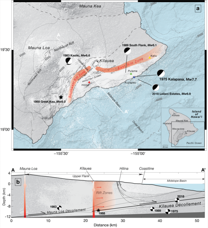
Researchers from the SOEST Department of Earth Sciences assessed an unprecedented 120 years of data from Kīlauea Volcano on Hawai‘i Island, uncovering, for the first time, century-spanning patterns of deformation and stress changes. They had a particular focus on the transformative 1975 magnitude 7.7 Kalapana earthquake, which also resulted in a 20-foot high tsunami. Their study was published recently in the Journal of Geophysical Research: Solid Earth.
“Deciphering Kīlauea’s history deepens our understanding of volcanic and seismic hazards,” said lead author Lauren Ward Yong, who conducted this study as part of her doctoral dissertation in Earth and Planetary Sciences. “It offers critical insights into how stress evolves in volcanic systems, guiding our ability to anticipate and interpret future earthquakes and magmatic events.”
The study highlights the hazard potential of the décollement, the major fault zone beneath Kīlauea volcano where two rock masses are moving past each other, which continuously drives the volcano southward and poses risks of large earthquakes coupled with complex volcanic activity within the region.
Yong and co-authors explored both the deformation and stress changes of the volcano from 1898-2018 by analyzing six different geodetic datasets. Their analysis encompassed 338,396 earthquake observations and more than 15,000 measurements of surface motion, or displacements, to construct a computational model replicating the observed displacements and stress before, during, and after the large 1975 Kalapana earthquake. This model pinpointed key structural features—fault planes, rift zones, and magma chambers—that drove these changes.
Altering stress and motion
They discovered that the 1975 Kalapana earthquake significantly altered the region’s state of stress and deformation. Prior to 1975, in the location where the large earthquake originated, there was no evidence of slip, a movement where two rock masses move past each other.
“This finding suggests that the region was likely frictionally locked and slowly accumulating stress over time leading up to the rupture,” said Yong. “Furthermore, we observed that Kīlauea’s south flank, a geologically active region stretching from the volcano’s summit toward the coastline, experienced greater and more complex displacement prior to the Kalapana earthquake than after.”
Yong and co-authors’ analysis of Kīlauea’s décollement, found the average slip was reduced from 10 centimeters per year before the 1975 earthquake, to just four centimeters per year afterward. These variations in slip and stress distributions along the décollement point to changes in mechanical properties, such as friction, that influence the region’s seismic and magmatic activity over time.
Enhancing hazard preparedness
“Hawai‘i’s communities live alongside active volcanoes and face significant seismic risks,” said Yong. “This research enhances hazard preparedness and reinforces UH’s commitment to advancing science for the safety and well-being of Hawai‘i’s residents and ecosystems by shedding light on past significant events.”
Kīlauea’s history offers invaluable insights into the complex relationships between magmatic processes and earthquake cycles. Building on this foundation, Yong and her team plan to refine their models by delving deeper into key properties of Kīlauea’s structural features, such as friction along fault planes, to improve understanding of how stress changes trigger seismic and magmatic activity.
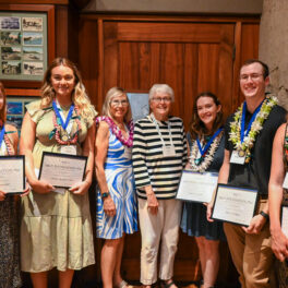
‘Ilima SACNAS SACNAS is an inclusive organization dedicated to fostering the success of diverse students, from college students to professionals, in attaining advanced degrees, careers, and positions of leadership in STEM.
“In hindsight, my upbringing was full of environmental science: moon phases and tides, geologic processes, ecosystem structure,” said Aaliyah Thomas, who is currently pursuing a bachelor’s degree in environmental earth science in the University of Hawai‘i (UH) at Mānoa School of Ocean and Earth Science and Technology (SOEST). “I was lucky to have been surrounded by people who made it fun and the classes I took in my secondary and post-secondary education helped me realize I had long been learning about environmental earth science.”
Born and raised in Waimānalo on the east side of Oʻahu, Thomas graduated from Kamehameha High School and, after the COVID pandemic settled down, attended Windward Community College (CC). Though she loves musical theater and earned an associate’s degree in Liberal Arts at Windward CC, Thomas really enjoyed her STEM-oriented classes most.
During her transition from Windward CC to UH Mānoa, Thomas enrolled in the Mauka to Makai oceanography course. This six-week summer bridge program proved to be a formative experience.
“This program introduced me to a lot more sophisticated lab work than I had experienced before,” Thomas shared. “This was so much fun because my research to assess the impact of mangrove removal (such as sedimentation and changes in microbial activity) on water quality at Heʻeia allowed me to get to know the ahupua’a of He’eia, both scientifically and historically. I also met mentors, including Rosie Alegado, Kuʻi Keliʻipuleole, and Diamond Tachera, who have become examples of how I hope to do science.”
Galapagos summer internship
While on the UH Mānoa campus, Thomas saw posters advertising an immersive research internship experience in the Galapagos Islands and was thrilled by the opportunity to visit the place that inspired Charles Darwin’s theory of natural selection. Additionally, the program emphasized place-based connections and indigenous resource management. Once she was selected for the program, she spent the spring semester preparing a project to analyze the water quality surrounding areas with a high abundance of an invasive algae.
“When I arrived I was told that they had run out of lab equipment crucial for my study, and that if we were to purchase more it would take too long to arrive; thus I was unable to do the water quality analysis.” Thomas explained. “It seemed like the whole research proposal, lugging around my field equipment from Hawai‘i to Galapagos, the hours put into preparation, was all for nothing.”
Turning challenge into opportunity
Living on the research station, Thomas visited the beach frequently and noticed there was always a sheen on the top of the water and that it was more obvious during low tide.
“The ocean water seemed less buoyant than what I was used to in Hawai‘i, and my teaching assistant, James Fumo, noticed little rivulets of water flowing from the rocks at the shore during low tide,” Thomas shared. “Sure enough when we tasted it, it tasted notably fresher than ocean water. Quickly my biggest challenge became the beginning of one of my most enjoyable experiences.”
Thomas suspected that this may be submarine groundwater discharge, a process that brings freshwater into the coastal zone from below ground, rather than over land such as through streams and runoff. Day after day, she tested the salinity across the shoreline at the Charles Darwin Research Center at low tide.
“My daily routine was led by the moon phases and tides, my ‘office’ was the beach, and the gym was a five minute bike ride from my sampling station,” said Thomas. “I was in heaven!”
James Fumo and Aaliyah Thomas on a kayak in Tortuga Bay using the YSI to measure salinity.
Research in support of sustainability, restoration
The island of Santa Cruz, Galapagos is thought to be waterless and prior to Thomas’s arrival, she was told by members of the research station that submarine groundwater discharge was not a factor on the island in the same way it is in Hawai‘i. However, all of her chemical data, and the lack of streams, runoff, and rain, suggested it is very plausible that what she was measuring was submarine groundwater discharge.
Aaliyah Thomas presenting her research findings for the Charles Darwin Research Station.
“This was an exciting discovery!” Thomas said. “My biggest hope is that my work in the Galapagos can help decision-makers who are responsible for that land. I hope that showing there’s SGD going into the Galapagos Marine Reserve will bring awareness to everyone within the watershed that their contaminants or over withdrawal can most definitely impact the coastal ecosystem they are so well known for.”
“I hope that whatever I do with my degree involves me putting my mana back into the land and its rehabilitation,” said Thomas, who anticipates graduating in Fall 2025. “I’m still exploring what that next step will look like.”
The School of Ocean and Earth Science and Technology (SOEST) received a donation of state-of-the-art software from PE Limited, one of the leading providers of structural geology software, that brings the total gift from the organization to $2,765,000. The initial donation from PE Limited in May 2019, valued at $2,180,000, a second gift in January 2020, and the 2025 contribution, provide Move suite software licenses that allow students and faculty in the SOEST Department of Earth Sciences to make advanced geological interpretations related to earthquake and tsunami generation.
The Move suite is the most complete structural modeling and analysis toolkit available. It provides a full digital environment for best practice structural modeling to reduce risk and uncertainty in geological models. The Move suite provides a platform for integrating and interpreting data, creating cross-sections to visualize subsurface layers, 3D model building of fractures and fault response, and fault and stress analysis.
The software is already up and running in the department and is licensed exclusively for teaching, tutorials, and non-commercial research. Providing access to this powerful software will advance SOEST students’ interpretation skills, making them much more attractive to future employers, and giving them an advantage for their studies of rock deformation.
“Our students very much appreciate PE Limited’s donation,” said Greg Moore, structural geologist and professor in the Department of Earth Sciences. “Having access to Move software takes our research into the tectonic processes at the Nankai and Hikurangi subduction zones to the next level. It allows us to understand how strain has been accommodated during subduction-related deformation, which will further our understanding of subduction zone earthquake hazards.”
“What an incredible opportunity it has been for our faculty and students to have access to a powerful, cutting-edge software package,” said Garrett Apuzen-Ito, Earth Sciences professor and department chair. “We are grateful for PE Limited’s generosity and partnership in helping advance our students’ professional experience and research impacts.”
This is an updated version of a story originally posted in December 2023.
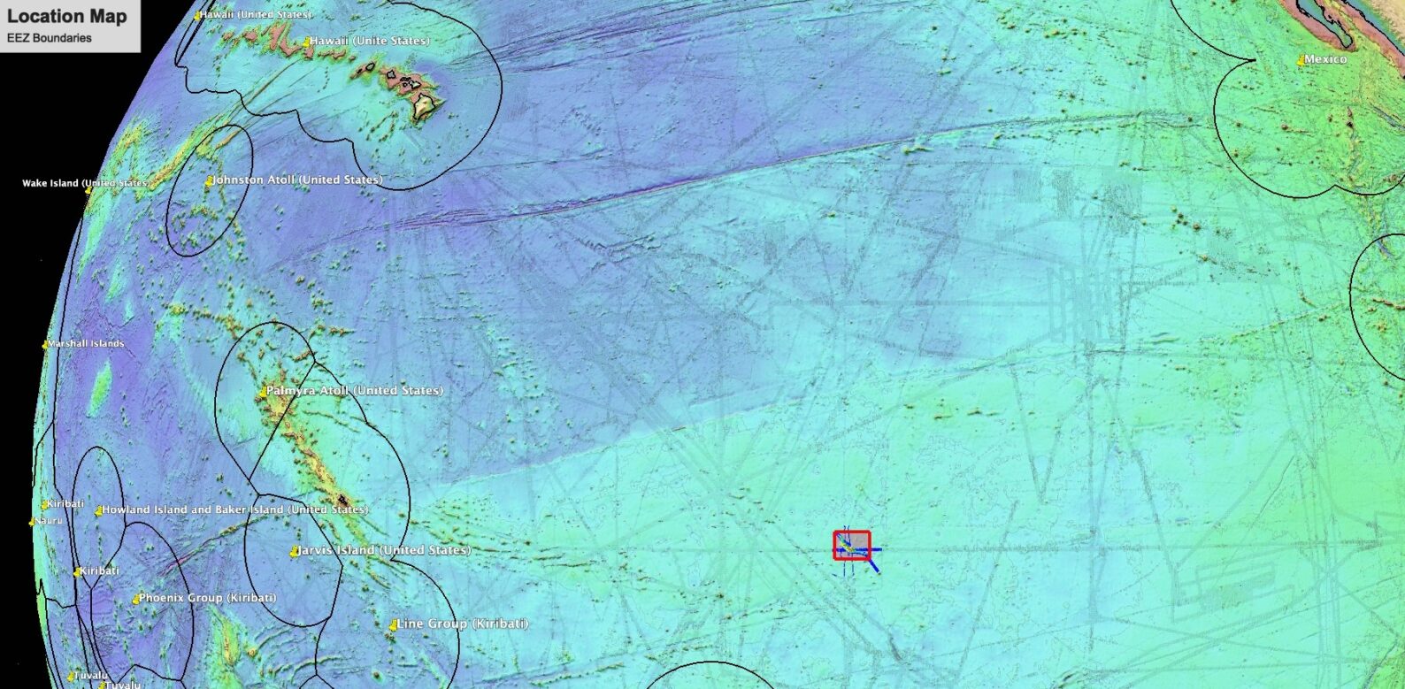
A large seamount southeast of Hawai‘i has been named Konter Ridge (0N, 135W) in honor of Jasper Konter (1977-2022), who was a professor of Earth Sciences at the University of Hawai‘i (UH) at Mānoa School of Ocean and Earth Science and Technology (SOEST). He is recognized globally for his research on oceanic volcanism and isotope geochemistry.
“This is a beautiful tribute and an especially fitting way to honor Jasper and his love for marine geology,” said Bridget Smith-Konter, SOEST Earth Sciences professor and Konter’s wife. “He loved sea-going research and nearly all of his research studies were focused on investigating the origins of seamounts, their geochemical fingerprints, and how these relate to tectonic plate motions and mantle plumes.”
Konter’s research was focused on understanding how long-lived, plume-fed Pacific hotspots generate age-progressive volcanic chains, such as the Hawaiian Islands and Samoan Islands, over 100-million-year timescales. His unique scientific contributions include using evidence from isotope geochemistry and mantle seismology to confirm the deep origin of mantle plumes, and to show that materials that were once subducted in the geologic past are returned again to the surface by these rising mantle plumes.
Through his research on the different stages of intraplate volcanism, Konter advanced scientific understanding of the evolving source materials and magma production mechanisms as volcanoes age. He and collaborators also used a combination of isotope geochemistry, lava rock ages, and volcano locations to identify motions of the Pacific Plate relative to plume-fed hotspots, as well as the motions of mantle plumes relative to each other. Konter and colleagues also developed methods for using non-traditional iron isotopes to identify source materials contributing to magma genesis at oceanic volcanoes.
Surveying Konter Ridge
Konter Ridge is an 89 km-long chain of seamounts on the ocean floor, straddling a zone across the equatorial Pacific about 35 km wide. At its tallest point, it stands 3 km above the surrounding seafloor, lying almost 1.5 km below the ocean surface. Thus far, Konter Ridge has been surveyed only 3 times by multibeam sonar expeditions: the first survey in March 1987 was aboard the R/V Thomas Washington; the second survey in 2009 was a transit of the R/V Knorr; and the third survey was in January 2024 aboard the UH vessel R/V Kilo Moana, where David Sandwell, Jake Perez, and Captain David Martin first proposed this name to honor their friend and colleague.
Location of Konter Ridge shown in red rectangle. Hawaiian Islands are visible in upper left of map.
Two days before what would have been Konter’s 47th birthday, Sandwell, a close colleague and friend of Konter and Smith-Konter; Perez, a dear friend of the couple; and Captain Martin, reached out to Smith-Konter and SOEST Dean Chip Fletcher, while at sea, to share their proposal.
“I was touched by their idea and intention to honor Jasper,” added Smith-Konter. “And I was captivated by its triangulated location amongst three of Jasper’s favorite places to study seamount evolution (each about 3500 km to Konter Ridge): Hawai’i, Jasper Seamount located near the Baja Peninsula [no relation to Konter], and Savai’i (Samoa). This effort, by our friends, to seek the official name of Konter Ridge for a massive, largely unexplored volcanic feature on the ocean floor, also carries a lot of sentimental value. It symbolizes friendship, collegiality, and the unique spirit of scientific curiosity and exploration.”
“We were thrilled to map a large seamount exactly on the equator to honor Jasper’s friendship and contributions to seafloor tectonics. During the survey, King Neptune hopped aboard the Kilo Moana for an equator crossing ceremony and a time to remember Jasper,” said Sandwell, in reference to a sailing tradition when a ship crosses the equator wherein those aboard who have not crossed previously are initiated by King Neptune and his court, portrayed by equator crossing veterans.
As the R/V Kilo Moana crossed the equator near Konter Ridge, those aboard who have not crossed previously are initiated by King Neptune and his court, which consist of equator crossing veterans.
“I’ve never forgotten his good humor (and equally matched intuition) when we were out at sea in 2013 (my first research expedition),” said Val Finlayson, former graduate student of Konter’s. “It was relatively early in the cruise and we had just brought a bunch of freshly-dredged rocks into the lab after cutting them open. Jasper walked up, looked at the rocks and announced, “Looks like HIMU!” and walked off. (And yes, after sophisticated testing, they later turned out to be HIMU!)”
“Jasper had a real taste for adventure,” said Matt Jackson, a friend and colleague of Jasper. “He was also a major skeptic of a lot of prior work done in ocean island geology and geochemistry, and I think this really motivated a lot of his work. But his intuition was almost always right.”
Fifteen years ago, Konter and Jackson had a two-day trek deep into the jungle in Savai’i, Samoa, to ground truth geology maps of the island made back in the 1950s.
“Jasper didn’t really believe the maps, which showed some unusually old rocks outcropping in the island’s interior,” said Jackson. “So we asked a local Samoan chief to guide us into the jungle. It was a real ‘Indiana Jones’ experience. The chief and his three sons guided us into the jungle, built a shelter, and then went foraging for food. We went looking for rocks. It was one of the most physically challenging things I’ve ever done, and we both had to go to a local medical clinic for treatment when we emerged from the jungle.”
But it was worth it, according to Jackson. “Jasper’s intuition and motivation to verify the maps helped us to better constrain the island’s volcanic stratigraphy.” This work has since inspired a plan to drill Savai’i to 2.5 km–to more fully constrain the island’s volcanic evolution–and it all traces back directly to Jasper’s adventurous spirit and approach to science. “I sure wish I could be working on this second chapter in the volcanic history of Savai’i with Jasper. He had an extraordinarily broad view of science across geophysics and geochemistry, and it was so much fun to work with him.”
“From his earliest days as a graduate student, Jasper traveled to Pacific seamounts to collect seamount samples so he could unlock the secrets of their origin and what that all means for our understanding of Earth as a dynamic geological and geochemical system,” said Hubert Staudigel, research geologist at the Scripps Institution of Oceanography and Konter’s PhD advisor. “He started this quest as a graduate student. He led an expedition to Jasper Seamount off Baja California (that only coincidentally carried his first name, named after Jasper the semi-precious stone). Subsequently, his seagoing travel took him from his home base to many other Pacific Seamounts, some of them all the way into the South-West Pacific. It is more than fitting for him to have a significant seamount in the Pacific named after him.”
Rock samples from Konter Ridge have yet to be recovered, but colleagues are eager to someday understand the origin, age, and geochemistry of this mysterious seafloor feature.
Beneath a miles-thick icy crust, Jupiter’s moon Europa likely has a saltwater ocean that may be one of the best places to look for life beyond Earth. Researchers in the Hawai‘i Institute of Geophysics and Planetology at the University of Hawai‘i at Mānoa were awarded $1.8 million from NASA to predict where they may have the best chance of accessing the liquid ocean and possibly finding life.
On Europa, liquid from the ocean may be exposed at the surface, or actively escape into space through plumes of vapor and ice particles. Such activity could also bring with it samples of microbial life that may inhabit the ocean. Sarah Fagents, researcher in HIGP at the UH Mānoa School of Ocean and Earth Science and Technology (SOEST), is leading the new effort to predict where the Europa Clipper, the mission to Europa that NASA launched on October 14, 2024, is most likely to find current-day activity, liquid water, and maybe even signs of life.
“This precursor work will provide critical context to enable more efficient analysis of Clipper data by the science community and will help generate discoveries and new questions that will feed into the planning of mission observations,” said Fagents. “This will maximize the science return during the lifetime of the Europa Clipper, which is limited due to the intense radiation it will experience around this moon.”
After traversing the solar system for nearly six years, Europa Clipper will reach Jupiter, orbit the planet, and conduct nearly 50 close flybys of Europa. In preparation for Europa Clipper’s arrival to the outer solar system, NASA funded projects to enhance and guide the data to be collected. Fagents’ three-year project includes HIGP researchers Shuai Li, Gwendolyn Brouwer, and Lauren Schurmeier; and collaborators from four other institutions (NASA Goddard Space Flight Center, Woods Hole Oceanographic Institute, the University of Texas at Austin, and Johns Hopkins Applied Physics Lab).
Clues from chaos
The team’s research will focus on what is referred to as Europa’s chaos terrains. These are highly fractured and disrupted areas of the moon’s surface where blocks of ice appear to have broken off, drifted and refrozen to the surface. Previous research has indicated that liquid water either rises directly from the ocean to the subsurface or forms by melting of salty ice at shallow depths, creating massive lakes inside the moon’s frozen crust. Over time, the ice directly above these lakes collapses, splintering into floating geometric fragments that rotate, raft and resettle into all kinds of chaotic configurations.
A close-up view of chaos terrain reveals jumbled blocks of ice that have refrozen to the surface. Credit: NASA/JPL/University of Arizona
Fagents’ project has several objectives to help guide the future collection of data on the Europa Clipper mission. The team will develop computer models to constrain the structure of the ice shell and whether it is brittle or ductile; better understand how the icy shell might respond and deform due to heat from below; and, together with laboratory experiments on salty ice mixtures, assess the role of liquid water in forming chaos terrain. The researchers will also employ machine learning methods to compare Europa Clipper and earlier spacecraft data to determine whether this terrain is actively forming today.
An artist’s interpretation of a subsurface lake formed inside Europa’s crust due to a rising plume of warm ocean water. Credit: NASA Visualization Studio
“With the upcoming work, we will assess the feasibility of different chaos formation models, determine the potential for exposure of interior and/or ocean materials at the surface, develop techniques for efficient analysis of Clipper data, and evaluate where best to look for signs of habitability exposed at the surface,” said Fagents. “I’m excited to see what’s ahead.”
For those wondering what lunar soil smells like, Marley Chertok, a graduate student working in the Hawai‘i Institute of Geophysics and Planetology (HIGP), will tell you that it smells like smoked meat in an old basement. Being able to be independent and focus on topics of interest to her while being homeschooled set Marley up for success in college studying geology. During her time in college at Temple University, she studied hydrology and worked for the The Academy of Natural Sciences in Philadelphia doing water quality research, furthering her laboratory expertise. However, Marley describes the field camp she did mapping geologic units in Wyoming and South Dakota as the most impactful towards her passion for field work.
“That experience contributed deeply to the geologist I am today,” she stated.
When she was nominated for an internship with the U.S. Geological Survey (USGS), she had the opportunity to work on the identification of spectral properties of cyanobacteria in order to better predict harmful algal blooms. This first exposure and work with spectroscopy, which is the study of how different objects absorb and radiate light in the electromagnetic spectrum, opened the door to other interesting applications of the science for Marley.
Transitioning into a more spectroscopy role, Marley was part of a team observing land use changes, and environmental impacts of refugee settlements in Zambia. In this study the research team was comparing the land use change of two different settlements, one in a tropical climate and another in a dry climate. The science team determined how protracted refugee settlements affect the environment and made recommendations for how emergency settlements can be better planned with both environmental and human needs in mind.
Shifting focus to space science
With more experience in remote sensing tools she got involved with the Astrogeology Science Center at USGS, where she worked studying the regolith on the Moon. Marley is currently pursuing a doctoral degree in Earth and Planetary Science at the University of Hawaiʻi at Mānoa. Immersed in research at HIGP with professor Paul Lucey, Marley recently defended her thesis focused on studying impact craters on the Moon.
“I started studying impact craters [and] I felt like I really understood it,” said Marley. “It is a fun challenge and I love being able to contribute little pieces [of knowledge] of solar system processes. It feels empowering and helps build confidence, and I hope to apply this information to other planetary bodies as well.”
Marley has been assessing impact craters to probe the subsurface of the Moon to better understand what the Moon was once like. Impact craters are a common tool used by planetary scientists to help date different areas of a terrestrial planet’s surface. As a general trend, older surfaces will have more craters. This is because more time will have elapsed and there will have been a longer period for craters to impact that area. Additionally, our solar system was once more chaotic than it is now and surfaces that were exposed during that time will have more craters.
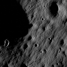
This image shows a cratered region near the moon’s Mare Nubium region
While new evidence shows that the Moon might still be geologically active, we know that it was previously far more active because we are able to see the remnants of extensive lava flows that have covered old cratered surfaces. These are the large dark patches you can see when looking at the Moon and are called lunar maria. The light areas of the Moon are the heavily cratered areas called the highlands. Marley’s research lies in understanding the nuances of the Moon’s surface and challenging the idea that lava flows on the Moon are homogeneous. The Moon’s lava flows may be more diverse than we expected.
In Marley’s work, she is comparing craters in the highlands to craters in the mare using ejecta blankets and crater depth to understand the Moon’s regolith, the top layer of unconsolidated material above the bedrock. When an impactor hits the lunar surface it excavates the regolith and throws rocks into the air, which land on the surrounding surface, this is called the ejecta blanket. More rocks strewn about around the crater is an indicator of a thin regolith.
Exploring solar system processes
Marley hopes that her work will take her “figuratively to the Moon and beyond. I hope that by understanding the Moon we can better understand the planetary processes of other bodies. We can use craters to shed light on the subsurface of planets.” She is also excited by how this kind of work changes when dealing with icy bodies. “Impact craters on ice will behave differently than rocky surfaces due to their composition and relative strength.”
Knowing that many terrestrial planets have icy surfaces, the future work in this area is vast. This is one of the things that she really enjoys about being part of HIGP, there are opportunities to “dabble in different areas of work.” On ‘dabbling,’ Marley sees this as a key to success, “I want to dabble in everything and have dabbled in a lot of things,” and suggests to other students that “It is good to try different fields, [at UH] it is not hard to get involved […] you have to practice pursuing things and be eager and interested. I tried a bunch of things and I am glad I did!”
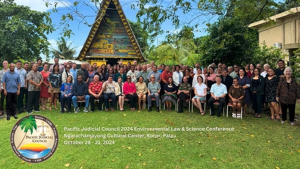
The University of Hawaiʻi at Mānoa played a pivotal role in the Pacific Judicial Council’s (PJC) Environmental Conference held in Palau, which featured discussions on the judiciary’s role in addressing pressing environmental challenges in the Pacific region. Faculty and students from the Kewalo Marine Laboratory (KML), William S. Richardson School of Law and Department of Natural Resources and Environmental Management (NREM) served as speakers and panelists at the October event.
Speakers included Nicole Yamase, who earned her PhD from UH Mānoa in marine biology in 2022, and Alexi Meltel, a UH Mānoa PhD candidate in marine biology, conducting her dissertation research in Palau and at KML. Yamase is Pohnpean, and the first Micronesian woman to earn her PhD in marine biology. Meltel, who is Palauan, will be the second.
Alexi Meltel and Nicole Yamase at the Pacific Judicial Council Environmental Conference
Experts noted that many of those challenges are now being addressed through lawsuits, and it is critical that the courts have the required knowledge to guide their decision-making.
“The fact that the Pacific Judicial Council is engaging with regional scientists is truly wonderful and cause for optimism that accurate science can lead to critically important outcomes that affect our natural resources and all who depend on them ecologically, economically and culturally,” said Research Professor and Director of KML Bob Richmond, who served as the conference organizer for the scientific panels.
The three-day conference focused on climate change, marine pollution, fisheries and economics as well as the intersection between law and science including recent court decisions.
“This conference provided invaluable education and training on the use of science as the core of decision making and action on the most pressing issues facing the Pacific, such as the protection of the marine environment and climate change,” said Professor Sherry Broder from the William S. Richardson School of Law, who provided the legal framework and context for addressing environmental problems in the courts. “Understanding how to use science as the basis for decision making in policy and law contributes to the development of protections of the environment.”
The audience included more than 100 judges, justices, legislators and leaders from across the Pacific, including Guam, Palau, the Federated States of Micronesia, Kiribati, Samoa, Tuvalu and the Marshall Islands.
“It was a unique and somewhat intimidating experience to translate science for justices, judges, and lawyers in the region,” said NREM Professor Kirsten Oleson, who presented on the economic impacts of environmental damage and degradation. “I enjoyed discussions about how science and law intersect. Many people seemed to appreciate learning how we rigorously assign monetary metrics to nature’s benefits. It is important to give them confidence in the numbers when, for instance, dealing with damage liability or safeguarding the public trust.”