


After Olivia Hawai‘i might get a two-week break
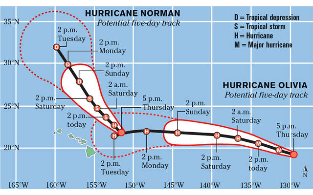 Graphic showing tracks of Hurricanes Norman and Oliva near Hawaiian Islands in September 2018. Source: National Hurricane Center
First there was Hector, followed by Lane. Next it was Miriam, with Norman on her heels. Olivia is on the horizon and appearing to threaten the islands next week. It’s been a busy month for the Central Pacific Hurricane Center, which since Aug. 6 has tracked three major hurricanes (Category 3 to 5) and another that reached Category 2 status.
With signs of a developing El Niño, it’s possible the parade of tropical cyclones marching across the Pacific will continue for the next couple of months and maybe even late into the hurricane season.
But one hurricane expert says we might be in for a break after Olivia passes — at least for a few weeks. “Sub-seasonal variability should be working to suppress hurricane activity in your part of the world for the next couple of weeks,” Colorado State University hurricane researcher Phil Klotzbach said Thursday.
Why has the past month been so busy for tropical cyclone activity in the Pacific? One reason is warmer- than-normal sea surface temperatures. “They’ve been really, really warm in the tropical belt of the North East Pacific and the Central Pacific,” said Pao-Shin Chu, professor of Atmospheric Sciences and Hawai‘i state climatologist.
Strong southwesterly wind shear — the changing direction of the wind’s speed or direction aloft over a short distance within the atmosphere — was credited for slowing down powerful Hurricane Lane and then tearing it apart before it had a chance to unleash its power on O‘ahu. “By and large, most hurricanes approaching Hawai‘i in the Central Pacific end up weakening because of wind shear,” said Steven Businger, professor and chairman of the Department of Atmospheric Sciences.
Read more about it in the Honolulu Star-Advertiser (subscription required).