


Hawai‘i plans for possibility of extreme tsunami
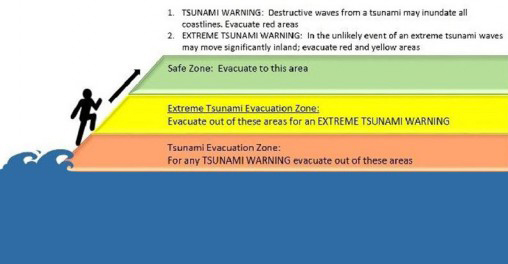 Detail of evacuation zone graphic; courtesy of Hawaii News Now.
The City & County of Honolulu has updated its tsunami evacuation zone maps, adding a second extended zone in case of an extreme tsunami like the one that struck Kaua‘i about 500 years ago. “In any person’s lifetime there’s like a 5% chance this will happen, so it’s a low probability but it’s high enough that we cannot ignore it,” said Gerard Fryer, Hawai‘i Institute of Geophysics and Planetology (HIGP) affiliate faculty and geophysicist at the Pacific Tsunami Warning Center (PTWC). “As people look at the new evacuation maps they’ll see there’s much more flooding. Then they’ll realize the power of one of these waves will potentially have a much greater effect on the islands than some of the events we’ve seen,“ said HIGP director Rhett Butler, the lead author of the “monster tsunami” paper.
Read more about it and watch the videos at KITV4 (autoplays) and Hawaii News Now. Link to draft maps and schedule of events at which representatives from the city’s Department of Emergency Management will be on hand to present the new maps, discuss the implications for O‘ahu residents, and answer questions. Also, read about the related archived news item “Evidence of ‘monster tsunami‘ found on Kaua‘i.” Image courtesy of Hawaii News Now.