


Rising seas could displace thousands of Ewa Beach residents
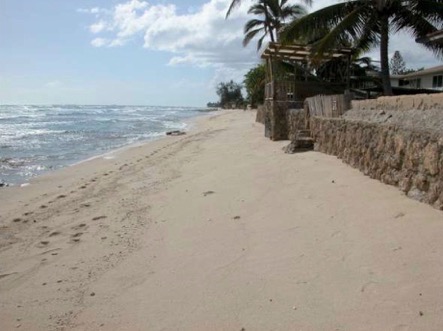 This stretch of Ewa Beach shows chronic erosion that has narrowed the beach to the point that homes are vulnerable to tsunami, storm surge, and high waves. Image via Honolulu Civil Beat.
Two years ago, research by SOEST revealed that flooding from the combination of a one-meter rise in sea level and a hurricane or a tsunami could affect 80 percent of the economy located between Pearl Harbor and Waikiki, with the total cost of those impacts reaching into the tens of billions of dollars.
Now, as part of the statewide effort to prepare a Sea Level Rise Vulnerability Assessment and Adaptation Report (SLR report) by the end of next year, as required under 2014’s Act 83, SOEST researchers have been focusing their sea-level-rise modeling efforts on areas outside Honolulu’s urban core, looking not at tsunami or storm surge-related flooding, but that associated with groundwater inundation, coastal erosion, seasonal (non-storm) wave inundation, and a 100-year coastal flooding event. Using their modeling results, consulting and engineering firm Tetra Tech has been analyzing the potential social and economic impacts, census block by census block.
At a sea level rise vulnerability and adaptation workshop in February sponsored by the state Department of Lands and Natural Resources, the state Office of Planning, SOEST and UH Sea Grant, Tetra Tech’s Catherine “Kitty” Courtney and SOEST associate dean Chip Fletcher provided a sobering glimpse of what could be in store for O‘ahu’s Ewa Beach, which already has a narrow, chronically eroding shoreline.
Read more about it in the Honolulu Civil Beat.