
|
University of Hawaii researchers capture unique volcanic mudflow event in New ZealandHonolulu, HI – Volcanologist Sarah Fagents from the School of Ocean and Earth Science and Technology (SOEST) at the University of Hawaii at Manoa (UHM) had an amazing opportunity to study volcanic hazards first hand and to document the effects when a volcanic mudflow broke through the banks of a volcanic lake while on a research trip to Mount Ruapehu in New Zealand. Fagents and colleague Bruce Houghton were there on a National Science Foundation (NSF) funded project to study the long-forecast Crater Lake break out lahar at Mount Ruapehu. (A lahar is a type of mudflow composed of water, pyroclastic material and other sediment that flows down from a volcano, typically along a river valley.) Lahars can be extremely hazardous, especially in populated areas, because of their great speed and mass. They can flow for many tens of miles, causing catastrophic destruction along their path. Lahars are commonly caused by the rapid melting of snow and/or glaciers during a volcanic eruption, or as in the case of Mount Ruapehu, the breakout of a volcanic lake. Fagents is the Principal Investigator on the NSF grant, and was one of the leaders of the student excursion. Sarah is working with New Zealand volcanologist Vernon Manville from the Institute of Geological & Nuclear Sciences, who coordinated the science response to the lahar. Along with UH and New Zealand colleagues, Fagents visited stretches of the lahar pathway 2-3 days before the breakout in order to assess pre-event channel conditions. Although the event was predicted to occur in 2007, the recent decreased filling rate of Crater Lake suggested that the lake bank would not be overtopped until 2008. However, several days of intense rainfall and increased seepage through the bank ultimately caused it to collapse on March 18, 2007. A lahar warning system was installed at Mount Ruapehu, coordinated by Dr. Harry Keys of the New Zealand Department of Conservation, and was hailed a success after it successfully alerted officials to the onset of the lahar. In total, about 1.3 million cubic meters of water was released from the Crater Lake, and this increased greatly in volume by incorporation of eroded sediments along the lahar pathway. A group of UH geology students joined the researchers for a class fieldtrip. “The lahar happened the day the GG601 students arrived in New Zealand, so we weren't able to get in and look at the aftermath until the following day,” explains Fagents. “However, the fresh deposit was spectacular. We got into a location about 40 km from source (the Tangiwai Bridge -- the site of a 1953 lahar disaster), and what we saw was a broad devastated area now covered in a veneer of mud and boulders. The threat was now effectively zero, as the lahar had passed the previous day, and so it was an unprecedented opportunity for the class to see the immediate aftermath of such an event. They produced an impressive group project interpreting flow conditions from the observations at Tangiwai. It's particularly motivating for the students to learn first-hand about lahar processes in such a dynamic environment.” Fagents, Houghton, and graduate students Chris Hamilton and Licia Costantini returned to New Zealand a month later to conduct a much more detailed analysis of the deposit. “Because the Crater Lake breakout had been long forecast, there was an unprecedented amount of instrumentation installed in the catchment by our New Zealand colleagues to capture the event,” says Fagents. “Because of this, the 2007 event will be by far the best studied lahar in the world.” Fagents is currently developing a computer model to simulate lahar emplacement and to predict the associated hazards. “Using the unique data set generated for this event to test my existing model, we will be able to verify that we have encapsulated the correct physics of lahar emplacement,” explains Fagents. “Our intent is then to adapt this model to account for different lahar triggering mechanisms, and for different locations, to make it more widely applicable. As an example, we have a collaboration in place with Jon Major of the USGS Cascades Volcano Observatory to use the model to study lahars at Mt. St. Helens. The ultimate goal is provide a useful hazards assessment tool for future lahars.
For Interviews contact Sarah Fagents, Hawaii Institute of Geophysics and Planetology, School of Ocean & Earth Science and Technology, University of Hawaii at Manoa, Honolulu, HI Phone: (808) 956-3163, fagents@higp.hawaii.edu Related links: Crater Lake bursts banks under scientists' noses – NewScientist.com (March 19, 2007)
PDF version of this release. |
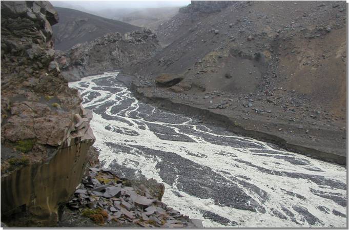
Images of the lahar channel before and right after the collapse of the Crater Lake walls. Yellow arrow points to the same rock outcrop on the channel bank. Photos by Rebecca Carey (top) and Sarah Fagents (bottom). |
|
 |
|
| Volcanologist Sarah Fagents ascending Mt Ruapehu to view Crater Lake after the dam breach. |
|
 |
|
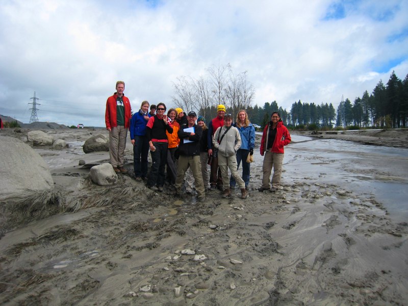
Students in the Geology and Geophysics 601 class at the deposit the day after the lahar. This was the site of the 1953 Tangiwai disaster, when a similar breakout lahar destroyed the rail bridge just minutes before a train arrived, causing the loss of 151 lives. (Photo credit: GG601 class) |
|
 |
|
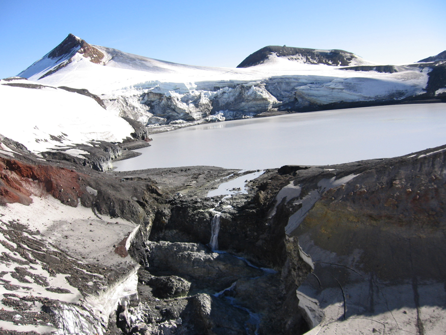
| Helicopter view of the Crater Lake dam breach three days after the lake breakout. Foreground shows the residual streamflow through the gap eroded in the tephra and snowpack. Photo credit: Rebecca Carey. |
|
 |
|
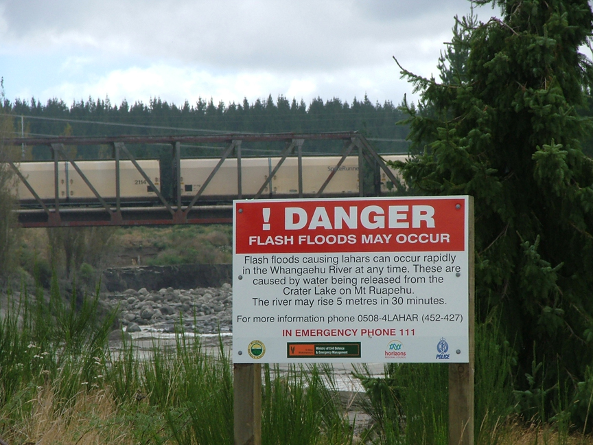
| Warning sign posted at the Tangiwai bridge approximately 40 km downstream from Crater Lake. Photo credit: Lynne Fagents. |
|
 |
|
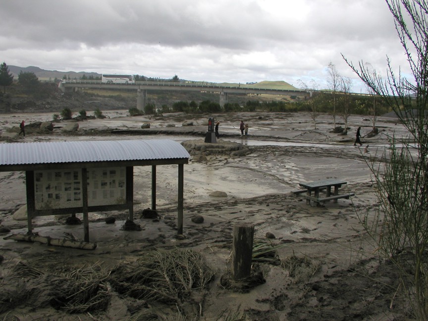
| The site of the memorial to the 1953 Tangiwai disaster the day after the March 18 2007 lahar. The lahar flow rose to within 2 m of the road surface on the bridge visible in the distance. Photo credit: Sarah Fagents |
|
News archives: 2015 • 2014 • 2013 • 2012 • 2011 • 2010 • 2009 • 2008 • 2007 • 2006 • 2005 • 2004 • 2003 • 2002Press release archives: 2015 • 2014 • 2012 • 2012 • 2011 • 2010 • 2009 • 2008 • 2007 • 2006 • 2005 • 2004 and earlierIf you have news to share, or would like more information about any of the above, please contact:
Mahalo! (Thank you!)
|
|


![]() Home |
Directory |
Education |
Research |
Facilities & Technology |
Public Resources |
News |
Contact Us
Home |
Directory |
Education |
Research |
Facilities & Technology |
Public Resources |
News |
Contact Us
Comments or questions about this page go to bays@hawaii.edu. Last update Mon 20 Apr 15.