Oahu Characteristics
Discussion of the implications of climate change on water resources in Hawaii will focus on the island of Oahu, specifically the Pearl Harbor basin (Figure 33). The basin and associated aquifer underlie part of Honolulu’s intensively developed urban area. In addition, there are extensively irrigated former sugar-cane, irrigated and non-irrigated pineapple, and upland pastures and forests. The basin’s climate is extremely varied with rainfall ranging from 500 to 6000 millimeters (19.7 to 236 inches) per year over a distance of only 25 kilometers (16 miles) (Figure 34). The maximum elevation of Oahu is 1231 meters (4,040 feet) at Kalaa peak.
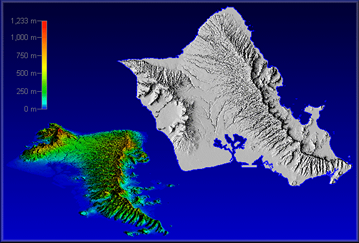
Figure 33. Oahu Island and the Pearl Harbor basin study area, which is the grey hatched area. Subdivisions or blocks are 1 square kilometer grid cells.

Figure 34. Median annual rainfall pattern of Oahu, Hawaii. Rainfall isopleths (n blue) are measured in inches per year. For example, the highest average rainfall for the Waianae Range is 80 inches per year.

Orographic processes are responsible for this wide range in rainfall (Figure 35). In addition, these orographic processes lead to wide spatial differences in cloudiness, solar radiation, and evaporation within the basin. The Pearl Harbor region is mainly dependent upon underground sources for its water requirements. Groundwater supplies Oahu with 92% of its water use. The development and use of the groundwater system have reached the point to where the sustainability of current and future water usage rates is in doubt.
Figure 35. Orographic rainfall. As air is forced upward over the mountain, it cools, causing water vapor to condense and fall out as rain.
