SYNOPTIC STRUCTURE AND
EVOLUTION OF A KONA LOW
Ian Morrison and Steven Businger
University of Hawai`i
Kona lows are subtropical cyclones that occur during the cool season in the north central Pacific (Simpson 1952, Ramage 1962). The Hawaiian word, kona, means leeward and is used to describe winds with a southerly component that replace the usually persistent trade wind regime. Historically kona lows have produced a variety of weather-related hazards, including heavy rains, hailstorms, flash floods, landslides, high winds, large surf and swell, waterspouts, and severe thunderstorms (Schroeder 1977a,b; Ramage 1995; Kodama and Barnes 1997; Businger et al. 1998).
 A subtropical cyclone or kona low affected the Hawaiian Islands from 24-28
February 1997 and brought with it record winds at Hilo, large hail and blizzard
conditions at higher elevations, and high surf (Figs. 1
and 2). Damage estimates for the storm due to crop
loss, property damage, and electricity and phone line outages exceeded four
million dollars (NOAA Storm Data 1997). A detailed case study of the storm was
conducted using all available operational data and data from the NCEP/NCAR
Reanalysis Data Set. The kona low formed on 23 February 1997 along a stalled
trough northeast of the Hawaiian Islands and is investigated during five
evolutionary stages (i) incipient, (ii) intensifying, (iii) mature, (iv) weakening,
and (v) dissipating (Fig. 2b).
A subtropical cyclone or kona low affected the Hawaiian Islands from 24-28
February 1997 and brought with it record winds at Hilo, large hail and blizzard
conditions at higher elevations, and high surf (Figs. 1
and 2). Damage estimates for the storm due to crop
loss, property damage, and electricity and phone line outages exceeded four
million dollars (NOAA Storm Data 1997). A detailed case study of the storm was
conducted using all available operational data and data from the NCEP/NCAR
Reanalysis Data Set. The kona low formed on 23 February 1997 along a stalled
trough northeast of the Hawaiian Islands and is investigated during five
evolutionary stages (i) incipient, (ii) intensifying, (iii) mature, (iv) weakening,
and (v) dissipating (Fig. 2b).
Generally, numerical weather prediction models do not reliably forecast kona low development and track. The models have difficulty simulating the mesoscale structures of these systems, a circumstance that is exacerbated by a lack of data over the central Pacific Ocean and insufficient model resolution (Fig. 3).

Satellite Views. Cloud bands with embedded convective cells characterized the early and mature stages of the kona low in satellite imagery (Figs. 4 and 5). The cloud bands form on the low's eastern side and propagate eastward, eventually leaving the area of synoptic scale ascent and losing their convective characteristics. Later in the life cycle, the cloud bands are less organized and convection appears more isolated. The average life span of the three synoptic-scale cloud bands was ~60 hours. Whereas the rainbands associated with the kona low tracked eastward, the storm.


Quasi-geostrophic
dynamics associated with a north-south oriented jet streak and
enhanced vorticity advection aloft was the mechanism for genesis
(Fig. 6). The jet streak occurred on the trailing
side of a developing upper-level trough. An enhanced pressure gradient on the
western side of the low was maintained as the circulation propagated westward
towards an upper-level ridge, thus enhanced winds remained on the western side
of the vortex throughout the low's life cycle.
Analyses suggest that high potential vorticity values, indicative of the intrusion of dry stratospheric air into the upper troposphere, induced enhanced positive advection of equivalent potential temperature (qe) near the surface (Figs. 5 and 7). It was shown that regions of deep convection, as inferred from satellite imagery, coincided with areas of low-level advection of warm, moist air as diagnosed by advection of qe. Regions of deep convection also matched areas where the Best-Lifted Index value was less than zero (Fig. 8).

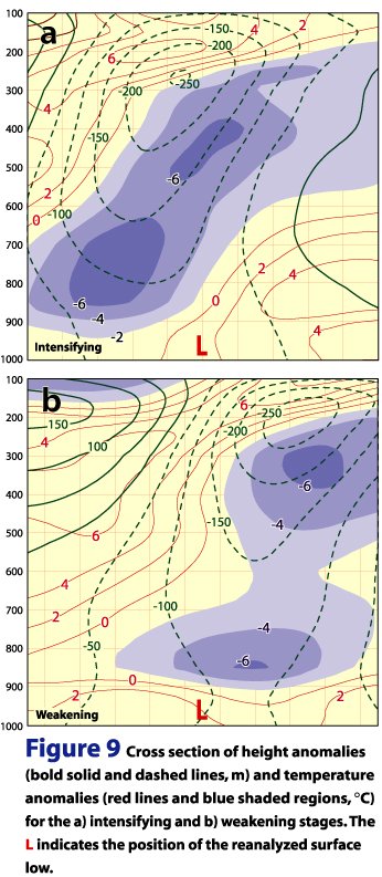
Vertical Structure. The 250-mb level exhibited the strongest absolute vorticity values and the greatest height anomalies, contrary to earlier investigations of kona lows that emphasized a 500 mb circulation (Fig. 9). The greatest temperature anomalies occurred along a vertically tilted axis extending from 850 mb in the west to 250 mb in the east. During the growth stages the axis of the negative temperature anomalies intersected the vertical plane of the surface low in the mid-troposphere, reducing the static stability (Fig. 9a). During the decaying stages the axis of temperature anomalies intersected the surface low near sea level, reflecting a more stable stratification (Fig. 9b). At the surface the isotherms showed a lack of baroclinicity, consistent with the equalizing influence from surface fluxes over a subtropical ocean on the cool-air side of the storm circulation.

Propagation. The Rossby-wave dispersion relationship was found to provide a good estimate of the zonal propagation speed of the kona low throughout its life cycle (Fig. 10).

REFERENCES
Businger, S., T. Birchard Jr., K. Kodama, P. A. Jendrowski, and J. Wang, 1998: A bow echo and severe weather associated with a kona low in Hawaii. Wea. Forecasting, 13, 576-591.
Kodama, K. R. and G. M. Barnes, 1997: Heavy rain events over the south-facing slopes of Hawaii: Attendant conditions. Wea. Forecasting, 12, 347-367.
Ramage, C. S., 1962: The subtropical cyclone. J. Geophys. Res., 67, 1401-1411.
____, 1995: Forecasters guide to tropical meteorology, AWS TR 240 Updated. AWS/TR-95/001, AWS, USAF, 392 pp. [Available from Headquarters AWS, Scott AFB, IL 62225.]
Schroeder, T. A., 1977a: Meteorological analysis of an Oahu flood. Mon. Wea. Rev., 105, 458-468.
____, 1977b: Hawaiian waterspouts and tornadoes. Mon. Wea. Rev., 105, 1163-1170.
Simpson, R. H., 1952: Evolution of the Kona storm: A subtropical cyclone. J. Meteorol., 9, 24-35.
![]()