SPECIAL SECTION:
Experimental Forecasts for Pacific Island Rainfall:
Ocean tides are a well-known example of "variability" in sea level, occuring on frequent and well-defined time scales. However, sea level also varies on other time scales due to other causes. Among these are: wind- and current-driven changes; short-term climatic variations; changes in global water-to-ice volumes; and relative variations of land and sea due to tectonic (geologic) processes. Direct measurements of sea level with tide gauges provides one of the largest sets of available records on ocean variability, extending over many decades, and complementing more modern techniques, such as global estimates of sea level variation using satellite altimetry heights. Experience has shown that large-scale events like ENSO, occurring on time scales from months to years and over spatial scales of several thousand kilometers, can be conveniently documented by monthly mean sea level deviations that are observable with data from tide gauges.
In the early 1970s, the University of Hawaii Sea Level Center (UHSLC) began installing tide gauges in the tropical Pacific to study the potential of sea level observations for ocean monitoring. Using data from this network of gauges, Professor Klaus Wyrtki presented the first detailed descriptions of the oceanic ENSO cycle in the tropical Pacific. Further development of this program over the intervening years has resulted in the Indo-Pacific Sea Level Network (IPSLN), presently the largest open ocean sea level network in the world operated by a single group. Since its establishment, UHSLC has served key roles in several national and international scientific research and observational programs. Among these are included: Tropical Ocean Global Atmosphere (TOGA) sea level database development; National Oceanographic Data Center (NODC) Joint Archive for Sea Level (JASL); World Ocean Circulation Experiment (WOCE) "Fast Delivery" Data Assembly Center (DAC); Integrated Global Ocean Services System (IGOSS) Specialized Oceanographic Center (SOC), and the IGOSS Sea Level Project - Pacific (ISLP-Pac). The UHSLC operates through primary funding under NOAA's Climate and Global Change program.
 Through its affiliation with IGOSS, UHSLC produced an early and very successful example of operational oceanography. Since June 1984, monthly maps of the Pacific sea level variations have been published without fail, drawing from monthly mean sea level data from a present count of 93 stations in 35 countries throughout the Pacific basin. Under WOCE, the UHSLC "Fast Delivery" data system provides near-realtime data from a network of 101 stations, used for example in validation of satellite altimetry estimates of sea level. In cooperation with NODC, UHSLC maintains a quality-verified sea level data base (JASL) from a global network of sea level stations, and is also continuing efforts to recover long time-series records that have previously failed to make it into other archives. A recent count of JASL holdings includes 4426 station-years of hourly quality-assured data. Most of this data is from the Pacific (with 193 stations, comprising 3140 station-years), but data sets from the the Atlantic (79 stations, 814 station-years) and Indian (63 stations, 472 station-years) Oceans are also substantial. UHSLC's data products can be accessed on an internet Wold Wide Web site, located at http://www.soest.hawaii.edu/UHSLC/. JASL data through 1994 is available on a CD-ROM, in cooperation with the NODC. In addition, direct mailings of the monthly sea level maps and indices are also available from UHSLC upon request.
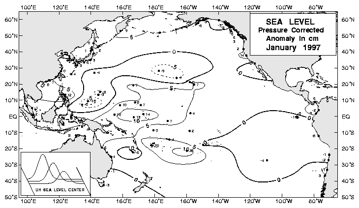
ENSO and Sea Level: Among the many changes in oceanic and atmospheric conditions related to ENSO is a pattern of west-to-east variation in mean sea level across the tropical Pacific. These variations in sea level are in turn related to the distribution of warm waters in the tropical Pacific, which tend to "float" on top of the deeper, cold waters below. During normal and La Niña conditions, much of this water is concentrated in the western tropical Pacific, where it is essentially "piled up" by easterly winds pushing sun-warmed ocean waters in from as far away as South America. This maintains a comparatively thick layer of warm water called the "warm pool" in the Western Pacific, also causing sea levels there to be slightly higher than in the east (this was the situation, for example, in late 1996). If the general pattern of winds in the region weakens or reverses (see SOI discussion, page 3), this "reservior" of warm water can start to shift position, spreading back out to the east in the form of slow-moving "Kelvin waves" which travel along the equator. Kelvin waves take several months to cross the Pacific and can be observed in many ways, but they are readily apparent in monthly and seasonal sea level changes recorded with the network of tide gauges in the tropical Pacific used by UHSLC. Sea level maps for the first four months of 1997 appear below, and show the beginnings of warm water movement from the wesern Pacific eastward, with sea levels dropping in the west and rising in the central and eastern tropical Pacific.
Sea Level Maps from UHSLC:

January 1997
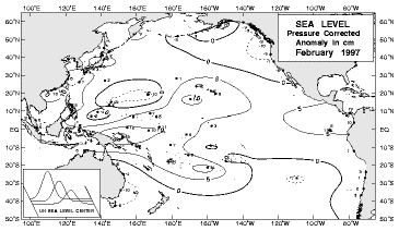
February 1997
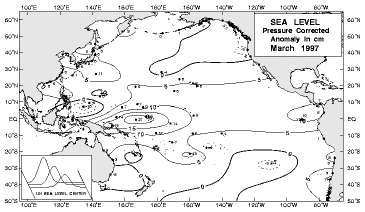
March 1997
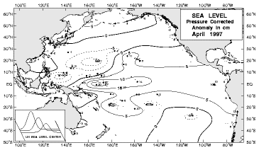
April 1997
Another measure of this ENSO-related shift in warm waters is made at UHSLC with an index for the "upper layer volume" of the tropical Pacific. Upper layer volume is defined as the amount of warm surface waters with temperatures greater than 20ºC (which overlay the deeper, colder waters below) in the tropical Pacific basin between 15ºN and 15ºS latitude. This is a huge volume of water, with an average value of about 70 x 10^14 cubic meters, or about the same as if an area the size of Australia were to be covered with water almost one kilometer deep! Typically, the upper layer volume is at a peak preceding an ENSO warm event, then decreases over the course of the event as warm water moves from the western Pacific toward the east, and then north and south along the coasts of the Americas and out of the region. Warm water volume begins to build up in the western Pacific again during the La Niña (cold event) phase of the cycle. A comparison of the upper layer volume index to the SOI (a well-known atmospheric indicator of ENSO condition) is shown in the figures below.
Further information about UHSLC is available via mail and telephone at:
U.H. Sea Level Center
Dept. of Oceanography
University of Hawaii at Manoa
1000 Pope Rd., MSB#307
Honolulu, Hawaii, USA 96822
808-956-6574
Southern Oscillation Index (SOI) and
Tropical Pacific Upper Layer Volume:
 The ENSO cycle is defined by trends in oceanic and atmospheric conditions, which in turn affect climate by changing normal weather patterns. One important measure of ENSO activity - the Southern Oscillation Index or SOI - is based on the differences in atmospheric surface pressure between Tahiti (in the south central Pacific) and Darwin (in northwest Australia). As such, the SOI gives information on the strength or weakness of normal easterly surface wind patterns in the tropical Pacific, compared to the long-term average. Negative values of SOI are associated with El Niño or ENSO warm events, and a weakening or reversal of normal wind patterns, while positive values of SOI are associated with La Niña cold-events and stronger-than-normal easterly winds in the region.
Associated with these changes in SOI and ENSO events are changes in the upper layer volume of the tropical Pacific (described in the text on page 2). In the graphs at right, a comparison of long-term values of SOI (top) to values for upper layer volume (bottom) shows that large drops in volume follow large drops in SOI by about 6-12 months. Such large changes are associated with ENSO warm events, and can be seen in these graphs for 1982-83, 1986-87, 1991-92, and 1994-95. These changes in upper layer volume are a result of the ENSO cycle, and therefore cannot be used to predict it. However, it is interesting to note that unusually high values of upper layer volume have preceded the onset of the ENSO warm events noted above, and that the high values for upper layer volume in early 1997, along with the recent drop in SOI, supports the possibility for further development of an ENSO warm event in the months ahead.
Back to Pacific ENSO Update - 2nd Quarter 1997- Vol.3 No.2
 Through its affiliation with IGOSS, UHSLC produced an early and very successful example of operational oceanography. Since June 1984, monthly maps of the Pacific sea level variations have been published without fail, drawing from monthly mean sea level data from a present count of 93 stations in 35 countries throughout the Pacific basin. Under WOCE, the UHSLC "Fast Delivery" data system provides near-realtime data from a network of 101 stations, used for example in validation of satellite altimetry estimates of sea level. In cooperation with NODC, UHSLC maintains a quality-verified sea level data base (JASL) from a global network of sea level stations, and is also continuing efforts to recover long time-series records that have previously failed to make it into other archives. A recent count of JASL holdings includes 4426 station-years of hourly quality-assured data. Most of this data is from the Pacific (with 193 stations, comprising 3140 station-years), but data sets from the the Atlantic (79 stations, 814 station-years) and Indian (63 stations, 472 station-years) Oceans are also substantial. UHSLC's data products can be accessed on an internet Wold Wide Web site, located at http://www.soest.hawaii.edu/UHSLC/. JASL data through 1994 is available on a CD-ROM, in cooperation with the NODC. In addition, direct mailings of the monthly sea level maps and indices are also available from UHSLC upon request.