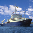
R/V Knorr June 15- July 15, 2007
| |
| Welcome |
| Meet the scientist and ship's crew |
| Science Overview |
| R/V Knorr |
| Daily Ship Life |
| Photo Gallery |
| Geology of Iceland |
| Links |
| For teachers |
| For students |
| Ask-a-Scientist |
| For Students... |
Here you will find an assortment of things to download and have fun with. Teacher to Student Blog (coming soon) Click here to download the Reykjanes Ridge Word Search Puzzle Maps for you to download: The maps below represent the three types of data were are collecting in this survey, magnetics, gravity, and bathymetry. It is interesting to see how the magnetics and gravity mimic the topography of the seafloor, called bathymetry. In both the magentics (fig. A) and gravity (fig. B) maps you are able to pick out the main seafloor topographic structures. In both figures A and B the most prominent reddish colored structure is the Reykjanes Ridge which extends above sea level at the Reykjanes Peninsula. To find out more about seafloor magnetic anomalies: http://www.divediscover.whoi.edu/ridge/magnet-polar.html
Click here to download the Magnetic Anomalies Map (.pdf) To find out more about seafloor gravity: http://www.divediscover.whoi.edu/hottopics/gravity.html
Click here to download the Gravity Map (.pdf) Topography map coming soon.
Works Cited : Gravity Data Set: Sandwell, D. T., W. H. F. Smith, Marine gravity anomaly from Geosat and ERS 1 satellite altimetry, Journal of Geophysical Research, v. 102 , No. B5, p. 10039-10054, 1997. Magnetic Anomalies Data Set: Verhoef, J; Roest, W R; Macnab, R; Arkani-Hamed, J; Magnetic anomalies of the Arctic and north Atlantic oceans and adjacent land areas, Geological Survey of Canada, Open File 3125a, 1996.
|


| Daily Log | ||
|
||