A Low-Relief Shield Volcano Origin for the South Kauaʻi
Swell
Garrett Ito1*, Michael O. Garcia1, John
R. Smith2, Brian Taylor1, Ashton Flinders3,
Brian Jicha4, Seiko Yamasaki5, Dominique Weis6,
Lisa Swinnard1, Chuck Blay7
*Corresponding Author: gito@hawaii.edu, 808-956-9717
1Department of
Geology and Geophysics, SOEST, University of Hawaiʻi,
Honolulu, Hawaiʻi 96822, USA
2Hawaii
Undersea Research Laboratory, SOEST, University of Hawaiʻi,
Honolulu, Hawaiʻi 96822, USA
3Graduate School
of Oceanography, University of Rhode Island, Narragansett, RI, 02882, USA
4Dept. of
Geoscience, University of Wisconsin, Madison WI 53706,USA
5Tono
Geoscience Center, Japan Atomic Energy Agency, Gifu, 509-5102, Japan
6Pacific
Centre for Isotopic and Geochemical Research, Department of Earth Ocean
Sciences, University of British Columbia, Vancouver, British Columbia, Canada
V6T 1Z4
7TEOK, Kauaʻi, Hawaiʻi, USA
Abstract
The South Kauaʻi Swell (SKS) is a 110 km x 80 km ovoid bathymetric feature that stands
>2 km high and abuts the southern flank of the island of Kauaʻi. The origin of the SKS was investigated using multibeam bathymetry and acoustic backscatter, gravity
data, radiometric ages, and geochemistry of rock samples. Most of the SKS rock samples are tholeiitic in composition with ages of 3.9-5.4 Ma
indicating they were derived from shield volcanism. The ages and compositions of the SKS rocks
partially overlap with those of the nearby Niʻihau, Kauaʻi and West Kaʻena volcano
complexes. The SKS was originally described
as a landslide; however, this interpretation is problematic given the ovoid
shape of SKS, its relatively smooth, flat-to-convex surface, and the lack of an
obvious source region that could accommodate what would be one of Earth’s most
voluminous (6 x
103 km3) landslides. The morphology, size, and the
surrounding gravity anomaly are more consistent with the SKS being a low-relief
shield volcano, which was partially covered with a small volume of landside
debris from south Kauaʻi and later with some
secondary volcanic seamounts. A shield origin would imply that Hawaiian and
possibly other hotspot shield volcanoes can take on a wider variety of forms
than is commonly thought, ranging from tall island-building shields, to smaller
edifices such as Kaʻena Ridge and Mahukona,
to even lower-relief volcanoes represented by the SKS and possibly the South West
Oʻahu Volcanic Field.
|
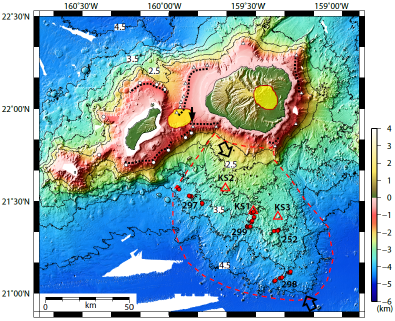
Multibeam
bathymetry data around Kauaʻi and Niʻihau from
our survey (KM0718) and from the Hawaiʻi Multibeam Synthesis (http://www.soest.Hawaiʻi.edu/HMRG/
Multibeam/index.php),
with 111 m grid spacing, colored and illuminated from the NW. Contours are every 0.5 km from depths of
4.5 km to 2 km. JASON dive numbers are
labeled; sample locations are marked with red circles; dredge numbers (KS1-3)
are labeled with locations marked by triangles. SKS is outlined with dashed
line and its central axis is marked by large arrows. Gravity anomaly highs (≥
+80 mGal) overly the inferred magmatic centers of
the two shield volcanoes are marked by translucent yellow patches [Flinders et al., 2010]. White symbols
mark locations of identified slope breaks, interpreted as the paleo-shorelines of Kauaʻi
(triangles) and Niʻihau (circles) [Flinders et al., 2010]. Dotted
lines indicate the sections where the slope break continues between the white
symbols. Small black arrow marks where
a slope-break of Kauaʻi’s terrace lies above a
slope-break of Niʻihau’s terrace. |
Perspective views of (a) existing bathymetry (b) reconstructed
bathymetry in the absence of SKS, with Kauaʻi’s paleo-shoreline interpolated between the identified paleo-shorelines (Figure 2), and (c) reconstructed
bathymetry with Kauaʻi’s paleo-shoreline
protruding southward so that it would account for the full volume of the SKS
above the shown abyssal seafloor. Contour
interval is 0.5 km and vertical exaggeration is 3:1 (a1) Close-up and (a2) profile
(location marked by A-A’ of inset map) of Kauaʻi’s existing
southern flank. (b1) Close-up and (b2)
profile of Kauaʻi’s southern flank reconstructed in
(b). No vertical exaggeration in (a2)
and (b2). |