[ Bathymetry | Backscatter | Optical Validation | Geomorphology ]
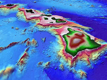
3D perspective view of the Main Hawaiian Islands data set maintained by the Hawaii Research Mapping Group (HMRG). Reproduced with permission from HMRG.
The Main Hawaiian Islands bathymetric data synthesis is maintained by the Hawaii Mapping Research Group (HMRG) and will soon be available for download at the HMRG website.
In the Main Hawaiian Islands, the Pacific Islands Benthic Habitat Mapping Center (PIBHMC) has focused on mapping shallow sites at high resolution. Release of the data is subject to the approval of the State of Hawai‘i, and will be available two years after the date of collection at the latest. PIBHMC will publish the data on this web page as soon as it is available.
Mapping of the Main Hawaiian Islands has been a collaborative effort. Many universities and research agencies have collected data around the Main Hawaiian Islands over the years, and those data are publicly available.
HMRG has been primarily responsible for synthesizing the data, in close cooperation witih PIBHMC, Hawaii Undersea Research Laboratory (HURL), and the School of Ocean and Earth Science and Technology (SOEST).
Contact Us
For more information, please contact us at:
- The Pacific Islands Benthic Habitat Mapping Center
- 1680 East-West Road, POST 833
- Honolulu, Hawai‘i 96822 USA
- tel: (808) 956-5239
- fax: (808) 956-6530
- email: pibhmc@soest.hawaii.edu