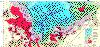
Mauna Loa: Geologic Map
provided by William Chadwick. This map is Figure 5 from the
paper
Moore, J.G., and W.W. Chadwick, Jr., 1995, Offshore Geology of
Mauna Loa and Adjacent Areas, Hawaii, in Rhodes, J.M. and
J.P. Lockwood (eds.), Mauna Loa Revealed: Structure,
Composition, History, and Hazards, American Geophysical
Union, Washington, D.C., pp. 21-44.
 [Image size: 1278x754 pixels: 91758 bytes]
For a smaller image (608x390 pixels, 169052 bytes) of the same map,
see AGU's page Mauna Loa
in technicolor.
Reconnaissance geologic map of south Hawaii region. Explanation of units:
- "Terrestrial lava" - Subaerially erupted and quenched, largely basaltic.
Tbh, historic; TbQ, prehistoric lava.
- "Submerged terrestrial lava" - Stb, submerged subaerial lava with
previous shorelines (commonly marked by coral reefs) shown by dotted
lines with apparent age in ka. Includes some post-submergence
subaerially-erupted lava flows that crossed the shoreline.
- "Fragmental quenched lava" - Fb, generated from subaerially-erupted lava
that crossed a shoreline and was subaqueously quenched and fragmented.
Largely sand-sized, but includes material to block size and some pillow
lava. Includes historic material offshore from historic lava ocean
entries.
- "Subaqueous lava" - Subaqueously erupted and quenched, largely basaltic
pillow lava. SbQ, Quaternary lava associated with Hawaiian Ridge; light
color where relatively flat. SbK, weathered Cretaceous basaltic lava of
non-Hawaiian seamounts that are heavily coated with MnFe oxides; similar in
age to the underlying Cretaceous oceanic crust.
- "Landslides" - Ls, slumps that are generally coherent, though faulted, and
La, debris avalanches that are extensively fragmented and contain isolated
blocks. General landslide names in upper case type.
- "Abyssal sediment" - As, includes pelagic sediment, turbidites, and
airfall volcanic ash.

